
Search Results


Westkust Celebes: Vaarwaters benoorden Makasser: Blad I
1898
Indonesia
Navigation map of the west coast of Celebes (Sulawesi), north of Makassar. Bathymetry (sea depth), lighthouses, shoals and other obstructions are marked, with trees and hills as landmarks, and elevations (side views of hills) to aid navigation.

Westkust Celebes: Vaarwaters benoorden Makasser: Blad III
1898
Indonesia
Navigation map of the west coast of Celebes (Sulawesi), north of Makassar. Bathymetry (sea depth), shoals and other obstructions are marked, with hills and settlements as landmarks, and elevations (side views of hills) to aid navigation.


Atlas van Nederlandsch Oost-Indië
c.1897-1904
Indonesia
Very detailed atlas of the entire Dutch East Indies, over 16 map sheets, with a cover and overview map. Includes topographic maps, inset maps of cities and islands, and maps featuring land and sea routes, languages, geology, colonial territory etc.


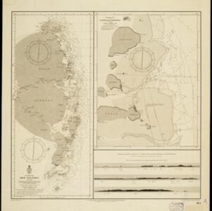
Oostkust: Aroe-Eilanden / Ankerplaats voor Watoelei en Koemoel
1896
Indonesia
Map of the east coast of the Aru Islands (Maluku Islands), with bathymetry (sea depth), tides and currents, shoals and other obstructions. An inset map shows the anchorage at islands off the coast, along with elevation views of the islands.
- Filter from 1818 to 1899
- [remove]Dutch East Indies81
- Sumatra37
- Java29
- Sulawesi21
- Celebes20
- Java Sea18
- South China Sea17
- Borneo16
- Malay Peninsula12
- Western New Guinea11
- Chineesche Zee9
- Maluku Islands9
- more Detailed Location »
- [remove]Maritime Route81
- Bathymetry69
- Tide Data22
- Current Data8
- [remove]Longitude and Latitude81
- Scale69
- Contour Lines/Elevation63
- Compass Rose43
- Written Note/Details20
- Rhumbline Network2


