
Search Results
Filter
Language
Dutch
Remove constraint Language: Dutch
Detailed Location
Western New Guinea
Remove constraint Detailed Location: Western New Guinea
Settlement Features
Kampong/Village
Remove constraint Settlement Features: Kampong/Village
Political Regions
Colonial Possessions
Remove constraint Political Regions: Colonial Possessions
Collections
Bodleian Libraries, University of Oxford
Remove constraint Collections: Bodleian Libraries, University of Oxford
3 Results found

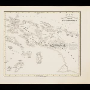
Kaart der Nederlandsche Bezittingen of het Eiland Nieuw-Guinea
1853
Indonesia
Map of Dutch colonial territory in New Guinea and nearby islands, featuring the 1850 route of the Dutch schooner Circe under Lieutenant Brutel de la Rivière. (From ‘Algemeene Atlas van Nederlandsche Indie [General Atlas of the Dutch East Indies]’.)


