
Search Results


Deutsche Kolonien
c.1896-1900
Indonesia, Papua New Guinea
From Joseph Kürschner’s ‘Universal-Konversations-Lexikon’, this map of German colonies includes the island of New Guinea. Divided between Dutch, British and German colonies, the German territory is Kaiser-Wilhelmsland and the Bismarck Archipelago.

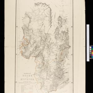
Overzichtskaart der residentie Wester-afdeeling van Borneo
1896
Indonesia
Map of western Borneo, divided into administrative districts. Mountains and larger settlements are marked with their height. A flag indicates a military garrison. A list of the districts notes their type of local ruler (Sultan, Prince etc.).
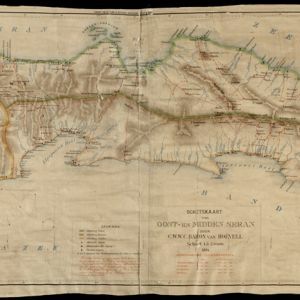
Schetskaart van West-Seran (Vulgo Ceram) / Schetskaart van Oost- en Midden Seran
1896
Indonesia
Map of the island of Seram in the Maluku Islands, originally produced as two separate maps. Red lines show lines of communication of local people (referred to as ‘Alfoer’), with their tribe’s name. Muslim, Christian and Alfoer settlements are marked.


Kaart van de residentie Oostkust van Sumatra
1896
Indonesia
Detailed topographical map of the east coast of Sumatra, spread over 36 sheets. The area’s farms are listed and shown on the map within yellow borders, with types of crop grown. There is a detailed plan of Medan, and five inset maps of other towns.

Map of Singapore and surrounding country
1896
Singapore, Malaysia, Indonesia
Map of Singapore Island, including the surrounding islands and straits, and southern Johor. Lighthouses are marked in red and yellow, including Horsburgh Lighthouse on Pedra Branca, Raffles Lighthouse and Fort Canning Lighthouse.


Sketch map of the Malay States, Kelantan and Trengganu, to illustrate the Paper by Hugh Clifford
1896
Malaysia
Map of the east coast of the Malay Peninsula, showing the route taken along the rivers and coast by Hugh Clifford, who was the British Resident at Pahang at the time. In addition to rivers, significant mountains and settlements are marked.


- Filter from 1669 to 1900
- Port48
- Railway Station33
- Pier15
- [remove]River410
- Road255
- Path157
- Railway/Tramway115
- Postal Route81
- Telegraph/Telephone32
- Canal30
- Bridge22
- [remove]District/Administrative Border410
- Colonial Possessions91
- National Border48
- Civic/Metropolitan Border42
- Regional Border28


