
Search Results
Filter
Cultural Regions
Religious Groups
Remove constraint Cultural Regions: Religious Groups
Land Features
Mountain/Volcano
Remove constraint Land Features: Mountain/Volcano
Political Regions
District/Administrative Border
Remove constraint Political Regions: District/Administrative Border
4 Results found

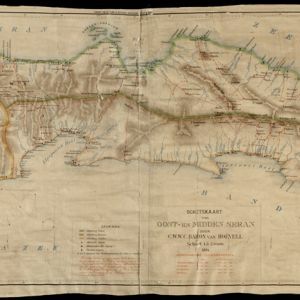
Schetskaart van West-Seran (Vulgo Ceram) / Schetskaart van Oost- en Midden Seran
1896
Indonesia
Map of the island of Seram in the Maluku Islands, originally produced as two separate maps. Red lines show lines of communication of local people (referred to as ‘Alfoer’), with their tribe’s name. Muslim, Christian and Alfoer settlements are marked.

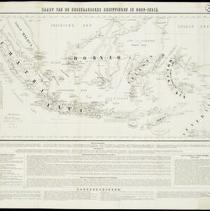
Kaart van de Nederlandsche bezittingen in Oost-Indië
1840
Brunei, East Timor, Indonesia, Malaysia, Philippines, Singapore
This map shows the Dutch colonial possessions in the East Indies in the mid-19th century. The text provides great detail about the people, religion, crops, animals, geography and administration of the Dutch East Indies.
- Filter from 1840 to 1900
- [remove]Religious Groups4
- Race/Ethnicity3
- Population Density1
- [remove]District/Administrative Border4
- Colonial Possessions1
- [remove]Mountain/Volcano4
- Wild Animals1


