
Search Results


Vaarwaters en ankerplaatsen op de Oostkust van Borneo: Blad I
1896
Indonesia
Four navigation maps of waterways on the northeast coast of Borneo, including the Karang Muaras reef. Anchorages, bathymetry (sea depth), shoals and other obstructions are shown, with trees, hills and elevations (side views of hills) as landmarks.


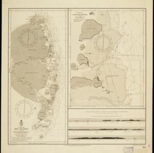
Oostkust: Aroe-Eilanden / Ankerplaats voor Watoelei en Koemoel
1896
Indonesia
Map of the east coast of the Aru Islands (Maluku Islands), with bathymetry (sea depth), tides and currents, shoals and other obstructions. An inset map shows the anchorage at islands off the coast, along with elevation views of the islands.

Vaarwaters en ankerplaatsen op de oostkust der Aroe-eilanden
1896
Indonesia
Four navigation maps of the waterways and anchorages around the east coast of the Aru Islands (in the Maluku Islands, near New Guinea). Bathymetry (sea depth), shoals and other obstructions are shown, with trees and villages to use as landmarks.

Vaarwaters en ankerplaatsen op de Zuidkust van Celebes
1896
Indonesia
Eight navigation maps from around the south coast of Celebes (Sulawesi). Anchorages, roadsteads (bodies of water sheltered from tides/currents), bathymetry (sea depth), shoals and other obstructions are shown, with hills and settlements as landmarks.


Zuidelijk gedeelte van de Chineesche zee: Blad I
1893
Malaysia, Indonesia, Singapore
Navigation map of the southern part of the South China Sea, including the straits of Malacca and Singapore, and the Riau Archipelago. Bathymetry (sea depth), lighthouses, shoals and other obstructions are marked, with hills to use as landmarks.

Gulf of Siam: Malay Peninsula - East Coast. Lakon Roads to Lem Tane
1880
Thailand
Produced by the British Admiralty’s Hydrographic Office, this map includes various navigational aids, such as maritime routes, bathymetry (sea depth), tide and current data, and elevations (side views of hills and mountains to use as landmarks).
- Filter from 1670 to 1899
- [remove]Compass Rose43
- Scale40
- Longitude and Latitude33
- Contour Lines/Elevation25
- Written Note/Details6


