
Search Results


Ankerplaatsen en mondingen van rivieren op de Noord- en Oostkust van Sumatra: Blad I
1896
Indonesia
Eleven separate maps of bays and river mouths of Sumatra, including two bays on the island on Bras (Breueh Island), and the bay at Kota Radja (Banda Aceh). Bathymetry (sea depth), anchor points, reefs and shoals are marked, along with tide data.

Sketch map shewing the rivers and an outline of the coast... Gulf of Papua, British New Guinea
1893
Papua New Guinea
Map of part of the east coast of the Gulf of Papua, with river mouths, shoals, bathymetry (water depth). On land, notes on terrain (‘Hills 100 to 150 ft. high’), land (‘Good soil’), vegetation (‘Nipa and Sago Palms’) and people (‘Ipikoi Tribe’).

Sketch map shewing the rivers and an outline of the coast... Gulf of Papua, British New Guinea
1892
Papua New Guinea
Map of part of the west coast of the Gulf of Papua, with islands, river mouths, shoals, bathymetry (water depth), notes to aid navigation. On land, notes on terrain (‘Limestone Hill’), vegetation (‘Pandanus & Nipa Palms’) and people (‘Paia Tribe’).

Westkust Borneo: Mond der Padang-Tikar rivier
1884
Indonesia
Navigation map of the mouth of the Padang Tikar River, on the west coast of Borneo, featuring bathymetric (water depth) routes. Obstructions are marked with letters: ‘m’ (mud), ‘z’ (sand). Trees, hills and fishermen’s houses are shown as landmarks.
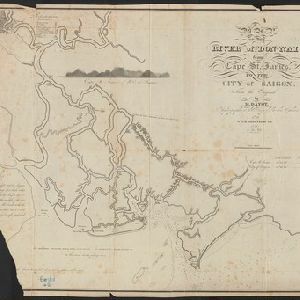
Map of the River of Don-nai from Cape St. James to the city of Saigon
1820
Vietnam
A map to aid in the navigation of the rivers leading to Saigon (Ho Chi Minh City, Vietnam). Details include bathymetry (water depth), currents, and a side view (or ‘elevation’) of hills to use as a landmark. Tides are described in written remarks.


