
Search Results
10 Results found


Algemeene kaart van Nederlandsch Oostindie
c.1839-1855
East Timor, Indonesia, Malaysia, Singapore
This map of the Dutch East Indies is spread over eight sheets, with a hand-drawn cover sheet showing the whole area. There are numerous inset maps of islands, bays, cities etc. Two of the inset maps have a replacement map pasted over them.

A new chart of the Oriental Seas and Islands... from the Isle of Ceylon to Amoye in China
1790
Brunei, Cambodia, East Timor, Indonesia, Laos, Malaysia, Myanmar, Philippines, Singapore, Southeast Asia, Thailand, Vietnam
A late 18th century maritime map of Southeast Asia, marked with expedition routes including the return of Captain Cook’s HMS Endeavour from Australia in 1770, and Captain Philip Carteret’s circumnavigation expedition in 1768.

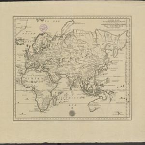
Nieuwe kaart van het oostelykste deel der weereld, dienende tot aanwyzing van de scheepstogten der Nederlanderen naar Oostindië
1753
Brunei, Cambodia, East Timor, Indonesia, Laos, Malaysia, Myanmar, Papua New Guinea, Philippines, Singapore, Southeast Asia, Thailand, Vietnam
This map of the Eastern Hemisphere was designed to show maritime routes from the Netherlands to Southeast Asia. It shows New Guinea (‘Nieuw Guinee’) and Australia (‘Nieuw Hollande’) as one landmass, connected via an area labelled ‘Karpentarie’.

Descriptio hydrographica accommodata ad battavorum navagatione in Javam insulam Indiæ Orientalis
1601
Brunei, Cambodia, East Timor, Indonesia, Laos, Malaysia, Myanmar, Philippines, Singapore, Southeast Asia, Thailand, Vietnam
This map shows the route of the first Dutch expedition to Southeast Asia in 1595-7. Led by Cornelis de Houtman, it was an attempt to enter the spice trade. The route crosses east over the Indian Ocean, circles the island of Java, and returns west.

Descriptio hydrographica accommodata ad battavorum navagatione in Javam insulam Indiæ Orientalis
c.1599-1628
Brunei, Cambodia, East Timor, Indonesia, Laos, Malaysia, Myanmar, Philippines, Singapore, Southeast Asia, Thailand, Vietnam
This map shows the route of the first Dutch expedition to Southeast Asia in 1595-7. Led by Cornelis de Houtman, it was an attempt to enter the spice trade. The route crosses east over the Indian Ocean, circles the island of Java, and returns west.
- [remove]East Timor10
- Indonesia10
- Malaysia10
- [remove]Singapore10
- Brunei8
- Cambodia8
- Laos8
- Myanmar8
- Philippines8
- Southeast Asia8
- Thailand8
- Vietnam8
- more Simple Location »
- Borneo10
- [remove]Celebes10
- Java10
- [remove]Maluku Islands10
- Sulawesi10
- Sumatra10
- Malay Peninsula8
- East Indies7
- Malakka7
- Western New Guinea7
- Pegu6
- Siam6
- more Detailed Location »
- [remove]Compass Rose10
- [remove]Longitude and Latitude10
- Scale7
- Written Note/Details4
- Rhumbline Network3
- Contour Lines/Elevation2


