
Search Results
99 Results found


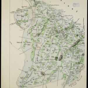
Kaart van de Vallei van Pidië, de Moekim VII en de Vallei van Tangsé
1899
Indonesia
Large-scale topographic map of the northeast coast of Sumatra around the city of Sigli, Aceh, spread over 16 sheets plus a cover sheet of the whole area. The map focuses on two river valleys, mountains, marshland, villages and rice paddies.

A map of British North Borneo
1899
Malaysia, Brunei, Indonesia
The colonial territories of British North Borneo are shown in pink on this late 19th century map, with Brunei and Sarawak in green, and Dutch colonial territory in yellow. Sea routes around the British Empire are depicted on an inset map.


Kaart van het gebied bezet in Groot-Atjèh
1898
Indonesia
A six-sheet map of Groot-Atjèh (Aceh, northern Sumatra) focusing on areas occupied during the Aceh War (1873–1904) between the Sultanate of Aceh and Dutch colonists. It shows military positions and fortifications, buildings, routes and crops.

Kaart de residentie Wester-afdeeling van Borneo
1898
Indonesia
Topographical map of western Borneo, with inset maps of the islands off the west coast, and of the city of Pontianak including the docks and crops grown near the city (rice, coconut, mangosteen, sago, alang-alang, indigo plant, sugarcane, bamboo).

Landbouw-ondernemingen in de afdeelingen Deli, Batoe Bahara en Asahan (Residentie Oostkust van Sumatra)
1898
Indonesia
On this map of the east coast of northern Sumatra, red borders divide the land into agricultural properties, each with a number to identify it. The whole area is divided into colour-coded administrative districts.


Kaart van het gebied bezet in Groot-Atjeh, met de nederzettingen Lepoeng en Lehoeng
1897
Indonesia
A map of Groot-Atjeh, Lepoeng and Lehoeng, at the northern tip of Sumatra, detailing routes (rivers, roads, railways), crops (rice, banana, sugarcane, betel, pepper, alang-alang, bamboo) and land features (forests, mountains, wetlands).

- Filter from 1816 to 1900
- [remove]Mountain/Volcano99
- Wetlands75
- Jungle/Wooded Area71
- Mangrove3
- [remove]Contour Lines/Elevation99
- [remove]Scale99
- Longitude and Latitude75
- Written Note/Details26
- Compass Rose12


