
Search Results
1321 Results found


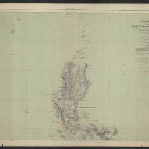
Carta general (en dos hojas) del Archipiélago Filipino
1900
Philippines
A Spanish military map of the northern Philippine island of Luzon, highlighting cable and telegraph lines, and aids to maritime navigation such as bathymetry (sea depth) and tide data. A conversion table for metres, fathoms and feet is also shown.

Commercial highways between United States and Asia and the islands of the Pacific
1900
Brunei, Cambodia, East Timor, Indonesia, Laos, Malaysia, Myanmar, Papua New Guinea, Philippines, Singapore, Southeast Asia, Thailand, Vietnam
The United States Treasury Department produced this map of trade routes crossing the Pacific Ocean between the United States and Asia. Each route is labelled with the names of its ports, and with the distance between them in miles.


Map of Asia: Printed for the New York Central's 'Four-Track Series'
1900
Malaysia, Indonesia, Thailand, Myanmar, Cambodia, Vietnam, Papua New Guinea, Philippines, Singapore, Brunei, Laos, Southeast Asia
Colonial territory is labelled and colour-coded on this map of Southeast Asia. A list on the left edge gives the colonial status, size and population of Asian countries, and ranks the main cities by population. Gold and iron mines are marked.

Map of the Kingdom of Siam and its dependencies
c.1900
Myanmar, Malaysia, Singapore, Thailand, Laos, Cambodia, Vietnam
The border of the Kingdom of Siam (Thailand) and its internal administrative districts are highlighted in yellow. Inset maps show the cities of Bangkok, Chiengmai (Chiang Mai) and Luang Pra Bang (Luang Prabang) in more detail.


- Filter from 1478 to 1900
- Indonesia1,105
- Malaysia752
- Myanmar688
- Thailand676
- Singapore664
- Vietnam628
- Cambodia620
- Brunei601
- Philippines585
- Laos570
- East Timor537
- Southeast Asia502
- more Simple Location »
- Port122
- Railway Station40
- Pier29
- River941
- Road268
- Path163
- Railway/Tramway130
- Postal Route91
- Telegraph/Telephone47
- Canal32
- Bridge24
- Legend471
- Cartouche381
- Inset Map292
- Illustration290
- Elevation134
- Coat of Arms101
- [remove]Longitude and Latitude1,321
- Scale900
- Contour Lines/Elevation480
- Compass Rose371
- Written Note/Details329
- Rhumbline Network124


