
Search Results
Filter
Map Attributes
Scale
Remove constraint Map Attributes: Scale
Map Attributes
Written Note/Details
Remove constraint Map Attributes: Written Note/Details
Insets
Legend
Remove constraint Insets: Legend
Land Routes
Road
Remove constraint Land Routes: Road
Political Regions
District/Administrative Border
Remove constraint Political Regions: District/Administrative Border
Political Regions
Regional Border
Remove constraint Political Regions: Regional Border
4 Results found


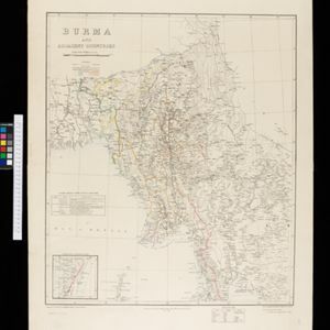
Burma and adjacent countries: With additions and corrections to boundaries and railways up to December, 1898
1898
Myanmar, Thailand
The regional and national borders of Burma and Siam are hand-coloured on this map. Provinces, districts and states within Burma are also highlighted, and itemised in a separate list.

- River4
- [remove]Road4
- Railway/Tramway3
- [remove]District/Administrative Border4
- [remove]Regional Border4
- Colonial Possessions3
- National Border3
- Longitude and Latitude4
- [remove]Scale4
- [remove]Written Note/Details4
- Contour Lines/Elevation1


