
Search Results


Queensland & British New Guinea
c.1894-1897
Indonesia, Papua New Guinea
The first two sheets of this eight-sheet map focus on British New Guinea, with German and Dutch colonial areas of New Guinea also shown in part. There is a line marking a proposed change in border between Dutch and British territory.

Oostkust Sumatra. Schetskaart der Siak Rivier van het Eiland Tengah tot Siak
1894
Indonesia
This late 19th century large-scale (1:30,000) map show just a section of the Siak River, in the Riau province of Sumatra. Bathymetry (water depth) is shown in figures to aid navigation, with various landmarks noted along the river’s banks.

Sumatra Oostkust: Monden der Koealoe en Panei rivieren
1892
Indonesia
Navigation map of the mouths of the Koealoe (Kualu) and Panei (Barumun and Bila) rivers on the east coast of Sumatra. Large sand and mud banks, bathymetry (sea depth), bouys and currents are marked. On land, tall trees are shown to use as landmarks.

Sketch map shewing the rivers and an outline of the coast... Gulf of Papua, British New Guinea
1892
Papua New Guinea
Map of part of the west coast of the Gulf of Papua, with islands, river mouths, shoals, bathymetry (water depth), notes to aid navigation. On land, notes on terrain (‘Limestone Hill’), vegetation (‘Pandanus & Nipa Palms’) and people (‘Paia Tribe’).

Map of British New Guinea
1892
Papua New Guinea, Indonesia
Map of British New Guinea, focusing on the sea (islands, shoals, reefs), coast (settlements, bays), mountains and land (‘dense forest’, ‘timbered with Eucalyptus’). Inset maps of Port Moresby, Samarai Island, and the whole island of New Guinea.

Map of part of Moratau (Fergusson Island) and Duau (Normanby Island): British New Guinea
1891
Papua New Guinea
Map of parts of Fergusson and Normanby islands (east coast of New Guinea). Bathymetry (sea depth), reefs and shoals are marked, along with landmarks (mountains, villages, trees). Territories of two indigenous tribes—the Subia and Manayaya—are shown.
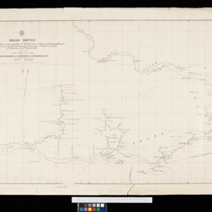
Rough Sketch of 200 miles of the western portion of British New Guinea, including rivers
1890
Papua New Guinea
Map of British New Guinea with notes on the terrain (‘Low country’), vegetation (‘Mangrove, Nipa and Fan Palms’), crops (‘Small plantations Sugar cane & Taro’), coastal features (‘Coral and Sand flats) and people (‘Friendly tribe’, ‘Dariamo Tribe’).

Map of the Fly River, British New Guinea, as traversed by Sir William MacGregor and party
1890
Papua New Guinea
Three maps on one sheet of the Fly River in British New Guinea, from the mouth to where it meets the Palmer River. Bathymetry (water depth) and sandbanks are marked at the mouth and landmarks—hills, vegetation, villages—are noted along the length.

Map of part of south-east New Guinea embracing its northern and southern waters
1889
Papua New Guinea
This map focuses on the southern coast including the capital Port Moresby, with the northern regions left mostly blank. There are four inset drawings of side views of mountains (elevations), and the border with German New Guinea is marked.

Plan of Port Moresby and the road to the Lolokie River: New Giunea
1887
Papua New Guinea
This map focuses on the capital city of British New Guinea, Port Moresby, and the road heading north-east from the city to the Laloki River. Along the road, there are descriptions of the terrain (‘Open flat fairly grasses timbered with bastard Gum’).


