
Search Results
Filter
Map Attributes
Written Note/Details
Remove constraint Map Attributes: Written Note/Details
Land Features
Mountain/Volcano
Remove constraint Land Features: Mountain/Volcano
Land Routes
River
Remove constraint Land Routes: River
Place of Publication
London
Remove constraint Place of Publication: London
Transport Hubs
Port
Remove constraint Transport Hubs: Port
3 Results found


New sketch map of the protected Malay State of Perak
1892
Malaysia
Map of state of Perak (Malay Peninsula) with a table of statistics: area, population, road/railway/river lengths, revenue, tin exports. Straits Settlements highlighted red. Someone has added handwritten travel times/distances by steamer/road/train.
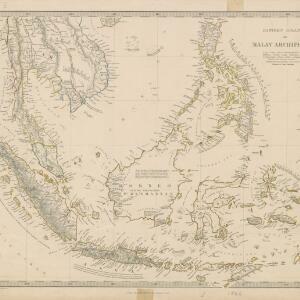
Eastern islands or Malay archipelago
1836
Brunei, Cambodia, East Timor, Indonesia, Laos, Malaysia, Myanmar, Philippines, Singapore, Southeast Asia, Vietnam, Thailand
Brief notes printed on this 19th century map of Southeast Asia provide details about each region, including: numbers and ethnicity of the population, local or colonial rulers, crops and products, geography (corals, forests, volcanos, earthquakes).
- Filter from 1836 to 1892
- [remove]Written Note/Details3
- Compass Rose2
- Contour Lines/Elevation2
- Scale2
- Longitude and Latitude1


