Search

Search Results

Kaart der Residentie Japara

event1858

location_onIndonesia

Map of the Dutch colonial administrative region (residency) of Japara (Jepara, Java). A cochineal factory—where the dye carmine is made from insects—is shown. (From ‘Algemeene Atlas van Nederlandsche Indie [General Atlas of the Dutch East Indies]’.)

Kaart van de Residentie Soerabaya

event1858

location_onIndonesia

Map of the Dutch colonial administrative region (residency) of Soerabaya (Surabaya, Java), including the Madura Strait and an inset map of the island of Bawean. (From ‘Algemeene Atlas van Nederlandsche Indie [General Atlas of the Dutch East Indies]’.

Kaart van het Regentschap Magelang

event1855

location_onIndonesia

Map of the Dutch colonial administrative region (regency) of Magelang, Java, with a list of places—mountains, villages—with their height above sea level. (From ‘Algemeene Atlas van Nederlandsche Indie [General Atlas of the Dutch East Indies]’.)

Kaart van de Residentie Kediri

event1855

location_onIndonesia

Map of the Dutch colonial administrative region (residency) of Kediri, Java. A list gives heights above sea level of some of the area’s mountains and villages. (From ‘Algemeene Atlas van Nederlandsche Indie [General Atlas of the Dutch East Indies]’.)

Kaart van de Afdeeling Ngrowo (Residentie Kediri)

event1855

location_onIndonesia

Map of the administrative department of Ngrowo, Java. A list gives heights above sea level of some mountains and villages, and a note locates a sugar factory. (From ‘Algemeene Atlas van Nederlandsche Indie [General Atlas of the Dutch East Indies]’.)

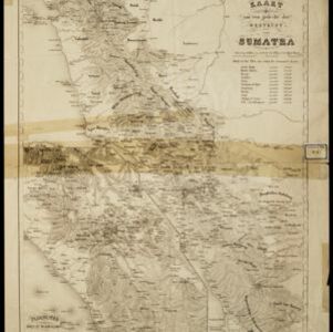
Kaart van een gedeelte der Westkust van Sumatra

event1855

location_onIndonesia

Hachures—short lines/dashes that give a sense of the shape and steepness of terrain—are used to show the mountains of Sumatra’s west coast, and of the Padang Highlands and Lowlands. Text lists the heights of some of the region’s chief mountains.

Kaart van het eiland Java

event1855

location_onIndonesia

Detailed map of Java based on the expeditions of the geologist and botanist Dr. Franz Junghuhn. There are 16 inset maps featuring volcanoes, mountains and coal seams.

Kaart van het eiland Java

event1855

location_onIndonesia

Detailed map of Java based on the expeditions of the geologist and botanist Dr. Franz Junghuhn. There are 16 inset maps featuring volcanoes, mountains and coal seams.

Algemeene Atlas van Nederlandsche Indie

eventc.1853-1862

location_onIndonesia

Atlas featuring over 60 detailed maps of the Dutch East Indies: 24 maps cover Java; the remainder cover the rest of the Dutch East Indies. There are three index maps. (All the maps in this atlas are also presented separately on this platform.)

Kaart der Nederlandsche Bezittingen of het Eiland Nieuw-Guinea

event1853

location_onIndonesia

Map of Dutch colonial territory in New Guinea and nearby islands, featuring the 1850 route of the Dutch schooner Circe under Lieutenant Brutel de la Rivière. (From ‘Algemeene Atlas van Nederlandsche Indie [General Atlas of the Dutch East Indies]’.)

Kaart van Java en Madura

event1850

location_onIndonesia

This map of Java and Madura uses hachures: short lines/dashes that give a sense of the shape and steepness of terrain. Roads, railways and rivers are marked, as are anchor points and coral reefs (marked with letter ‘K.’ before their name).

Kaart van Java en Madura

event1850

location_onIndonesia

This map of Java and Madura uses hachures: short lines/dashes that give a sense of the shape and steepness of terrain. Roads, railways and rivers are marked, as are anchor points and coral reefs (marked with letter ‘K.’ before their name).

close

  • Filter from 1850 to 1858

Current results range from 1850 to 1858