
Search Results


Midden-Sumatra: Reizen en onderzoekingen der Sumatra-expeditie... 1877-1879
1882
Indonesia
An Atlas produced by an expedition in central Sumatra, including: maps of topography, geology, a number of rivers in the region; drawings of mountains, graphs of lengths of roads; family trees of the royal families of Djambi (Jambi) and Palembang.
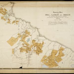
Figuratieve kaart van Deli, Langkat en Serdang met aanteekening der uitgegeven kontrakten
1876
Indonesia
Map of three regions on the northeast coast of Sumatra, with each region divided into parcels of land which are labelled with the name of a company. Presumably, these companies have been issued the contracts mentioned in the map’s title.

- Filter from 1602 to 1893
- Longitude and Latitude4
- [remove]Written Note/Details4
- Scale3
- Contour Lines/Elevation2


