
Search Results


Isole dell'Indie divise in Filippine, Molucche e della Sonda
1680
Brunei, Cambodia, East Timor, Indonesia, Malaysia, Laos, Myanmar, Philippines, Singapore, Southeast Asia, Thailand, Vietnam
Dotted lines and colours divide maritime Southeast Asia into three regions on this map: the Philippine archipelago, Maluku Islands and Sunda Islands. The cartouche features cherub mermaids, and a map of mainland Southeast Asia is on the reverse.

Isole Molvcche
1605
Brunei, Cambodia, Indonesia, Laos, Malaysia, Philippines, Singapore, Southeast Asia, Thailand, Vietnam, East Timor
This map shows some inaccuracies, especially in the shape of the Malay Peninsula and the islands meant to represent Sumatra (labelled ‘Camatra’), Java (‘Iava Mazor’) and Borneo (‘Iava Menor’). Latin text describes the Maluku Islands.
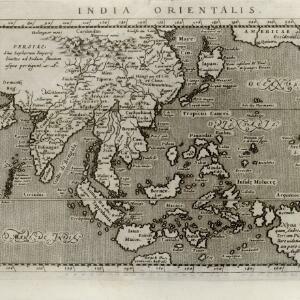
India orientalis
c.1597-1617
Brunei, Cambodia, East Timor, Indonesia, Laos, Malaysia, Myanmar, Philippines, Singapore, Southeast Asia, Thailand, Vietnam
Latin text written on New Guinea explains that it is uncertain whether it is an island or part of ‘Australis’ (‘southern land’) a name that was used for a continent thought to exist in the region (and after which Australia was eventually named).
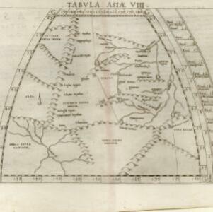

Tabvla Asiae XI
1574
Cambodia, Indonesia, Malaysia, Laos, Myanmar, Singapore, Thailand, Vietnam, Southeast Asia
Mid-16th century map by Girolamo Ruscelli, based on the work of 2nd century geographer Ptolemy. It is difficult to pinpoint exact locations, but the Malay Peninsula is recognisable. Italian text on the reverse describes the region.

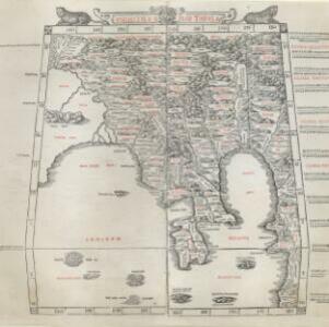
India tercera nvova tavola
1561
Cambodia, Indonesia, Laos, Malaysia, Myanmar, Philippines, Singapore, Southeast Asia, Thailand, Vietnam, Brunei
This mid-16th century map of Southeast Asia shows some inaccuracies, especially in the shape of the Malay Peninsula and the islands meant to represent Sumatra (labelled ‘Camatra’), Java (‘Iava Mazor’) and Borneo (‘Iava Menor’). Latin text on reverse.

Tabvla Asiae XI
1561
Cambodia, Indonesia, Malaysia, Laos, Myanmar, Singapore, Thailand, Vietnam, Southeast Asia
Mid-16th century map by Girolamo Ruscelli, based on the work of 2nd century geographer Ptolemy. It is difficult to pinpoint exact locations, but the Malay Peninsula is recognisable. Italian text on the reverse describes the region.
Vndecima Asiae Tabvla
1511
Cambodia, Laos, Malaysia, Myanmar, Singapore, Thailand, Vietnam
Based on the work of 2nd century geographer Ptolemy, Bernardo Silvani’s woodcut map is innovative in its use of two colours: a black background with important text added in red. The Malay Peninsula is labelled ‘Aurea Chersonesus [Golden Chersonese]’.


