Search

Search Results

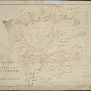
Kaart van de Residentie Preanger Regentschappen: No. II

event1857

location_onIndonesia

Map of the Dutch colonial administrative region (residency) of Preanger Regentschappen, Java with warehouses, factories, mills, cinchona (‘kina’) plantations. (From ‘Algemeene Atlas van Nederlandsche Indie [General Atlas of the Dutch East Indies]’.)

Kaart der afdeeling Poerbolingo: Residentie Banjoemaas

event1857

location_onIndonesia

The legend on this hand-drawn map of the district of Poerbolingo (Purbalingga), Central Java, includes ‘hoofd plaats [main town]’, ‘dessa [village]’, ‘doekoeh [farm]’, ‘indigofabriek [indigo plant mill]’ and ‘koffypakhuis [coffee warehouse]’.

Kaart van de voornaamsten der Banda Eilanden

event1854

location_onIndonesia

Map of the Banda Islands, with a volcano on Goenong Api, two forts (‘Ft. Belgica’ and ‘Ft. Nassau’) on Neira, and a list of the heights of the mountains. (From ‘Algemeene Atlas van Nederlandsche Indie [General Atlas of the Dutch East Indies]’.)

Algemeene Atlas van Nederlandsche Indie

eventc.1853-1862

location_onIndonesia

Atlas featuring over 60 detailed maps of the Dutch East Indies: 24 maps cover Java; the remainder cover the rest of the Dutch East Indies. There are three index maps. (All the maps in this atlas are also presented separately on this platform.)

Kaart van Onrust en bijliggende eilanden in het jaar 1837

event1840

location_onIndonesia

Map of the Dutch town and naval base on the island of Onrust in Batavia (Jakarta) Bay, and adjacent islands, featuring the dock, boat and work sheds, ammunition stores, forge, hospital and housing. Shoals, reefs and bathymetry (sea depth) are marked.

Plan of the town of Singapore

event1828

location_onSingapore

Known as the ‘Jackson Plan’, this is the earliest known plan of the city of Singapore, created by Lieutenant Philip Jackson in 1822. It was based on how Sir Stamford Raffles wanted Singapore to be developed, rather than the actual layout of the time.

Map of the River of Don-nai from Cape St. James to the city of Saigon

event1820

location_onVietnam

A map to aid in the navigation of the rivers leading to Saigon (Ho Chi Minh City, Vietnam). Details include bathymetry (water depth), currents, and a side view (or ‘elevation’) of hills to use as a landmark. Tides are described in written remarks.

[Havenkanaal: Platte grond teekening]

event1813

location_onIndonesia

A hand-drawn plan of the wharf at the ‘Haven Kanaal [Harbour Canal]’ port in Batavia (Jakarta), showing warehouses and other buildings along the ‘Groote Rivier [Big River]’ canal. There are two profile drawings of parts of the wharf’s retaining wall.

Grundris der stadt und citadelle Batavia

event1785

location_onIndonesia

A plan of the port of Batavia with a detailed legend identifying parts of the city. The sword and laurel wreath of the city’s coat of arms, and the Dutch East India Company flag (marked ‘VOC’ or ‘Vereenigde Oost Indische Compagnie’) are also shown.

Plan der stad en 't kasteel Batavia

event1780

location_onIndonesia

A plan of the port of Batavia with a detailed legend identifying parts of the city. The sword and laurel wreath of the city’s coat of arms, and the Dutch East India Company flag (marked ‘VOC’ or ‘Vereenigde Oost Indische Compagnie’) are also shown.

Batavia

eventc.1772-1780

location_onIndonesia

A plan of the port city of Batavia in the 18th century. Small ships can be seen transporting goods along the river to the pier, and the street plan also includes churches, shopping areas and hospitals, as noted on the map’s detailed legend.

A plan of the city and castle of Batavia

event1746

location_onIndonesia

A mid-18th century plan of Batavia (Jakarta), the main port of the Dutch East India Company's trading network in Southeast Asia. Ships can be seen transporting goods along ‘The Great River’ to the sea, overseen by Batavia Castle at the river’s mouth.

close