
Search Results

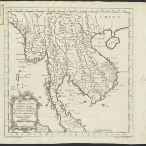
Carte de l'Inde au-delà du Gange comprenant les Royaumes de Siam, de Tunquin, Pegu, Ava, Aracan &c.
c.1757
Cambodia, Laos, Malaysia, Myanmar, Thailand, Vietnam
The kingdoms of mid-18th century mainland Southeast Asia are shown on this map: Ava and Pegu (Myanmar), Siam (Thailand), Tonquin and Cochinchine (Vietnam), Camboie (Cambodia) and Laos. Rivers are also prominent, and mountains are shown pictorially.


Plan d'Amboine, tel qu'il étoit en 1718 = Platte-grond van Amboina, zoo als het was in den jaare 1718
c.1746-1770
Indonesia
This colourful mid-18th century plan of the city of Amboine (Ambon, capital of Ambon Island, in the Maluku Islands, Indonesia) has a detailed legend identifying locations within the city and the surrounding mountains. The text is in French and Dutch.
- Filter from 1746 to 1772
- Bellin, Jacques Nicolas4
- [remove]Schley, Jacobus van der4
- Prévost, Abbé2
- Lodewycksz, Willem1
- [remove]Paris4


