A topographic map of the Burma-China border spread over five sheets. High points are marked with their heights so they can be used for triangulation. Settlements, rivers, trade routes and footpaths are also shown.
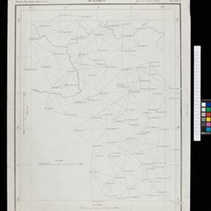
Burma-China Boundary Commission: Reconnaissance map. Southern party
event1900
location_onMyanmar
A topographic reconnaissance map of the Burma-China border. High points are marked with their heights so they can be used for triangulation. Settlements, rivers, trade routes and footpaths are also shown.
Burma
event1899
location_onMyanmar
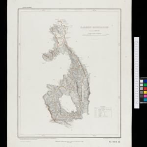
A large-scale topographical map of the states of Hsipaw, Lawksawk and Mongkung, within the Shan State of Burma (Myanmar). Elevation is indicated by contour lines, and travel and trade routes, villages, areas of cultivation and markets are also shown.
Skeleton map of India
event1899
location_onMyanmar
On this map of India, Burma (Myanmar) is divided into two regions: ‘British Burma’—under British colonial rule after the Second Anglo-Burmese War (1852)—and Upper Burma (labelled ‘Burma’), under British rule after the Third Anglo-Burmese War (1885).
Chart of triangulation: No.21 Party, Northern Shan States (Upper Burma)
event1899
location_onMyanmar
A triangulation map of part of Upper Burma (Myanmar), showing dozens of locations joined with straight lines to create a triangulation network.
Upper Burma
event1898
location_onMyanmar, Thailand
Map of Upper Burma divided into Divisions and Districts, and featuring the Irrawaddy and Chindwin rivers, the Burma State Railway, and settlements including the city of Mandalay.
Karenni boundaries
event1898
location_onMyanmar
Map of the four Karenni States—Nammekon, Naungpale, Bawlake, Kyebogyi—in Burma (modern Kayah State, Myanmar) and surrounding areas. Mountains are represented by hachures: short lines/dashes that give a sense of the shape and steepness of terrain.
India
event1898
location_onIndonesia, Malaysia, Myanmar, Thailand
British Burma is coloured pink on this six-sheet map of India. Mountains are represented by hachures—short lines/dashes that give a sense of the shape and steepness of terrain—and settlements, railways, roads, rivers and lighthouses are marked.
Burma-Siam boundary
event1897
location_onThailand, Myanmar
A topographic map of the Burma-Siam (Myanmar-Thailand) border spread over six sheets. High points are marked with their heights so they can be used for triangulation. Settlements and streams are also shown.