
Search Results
16 Results found


Svmatra cum circumiacentibus insulis
1601
Indonesia, Malaysia, Singapore
A colourful early 17th century map of Sumatra, Java and the Malay Peninsula, with North located to the left, and major settlements marked. Latin text on the reverse describes the peoples, religions, languages, agriculture, mining etc. of the region.


India quae Orientalis dicitur, et insvlae adiacentes
1664
Brunei, Cambodia, East Timor, Indonesia, Laos, Malaysia, Myanmar, Philippines, Singapore, Southeast Asia, Thailand, Vietnam
French text on the reverse of this map describes the religion, languages, crops, trade etc. of Aracam and Pegu (Myanmar), Siam (Thailand), Cambaja (Cambodia). The map is dedicated to the Dutch merchant Christophoro Thisio.
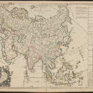
L'Asie suivant les dernres. observons. des Moscovites
1747
Brunei, Cambodia, East Timor, Indonesia, Laos, Malaysia, Myanmar, Philippines, Singapore, Southeast Asia, Thailand, Vietnam
The title of this mid-18th century map translates as ‘Asia following the latest observations of the Muscovites/Russians’. Written notes in French list the regions, islands, empires, kingdoms, colonial possessions, religions and languages of Asia.

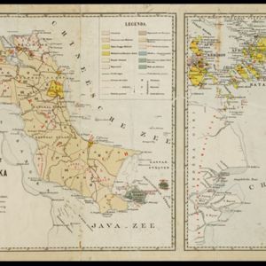
A language map of Further India and the Indian Archipelago
1878
Southeast Asia, Brunei, East Timor, Indonesia, Malaysia, Philippines, Singapore, Thailand, Vietnam, Myanmar, Laos, Cambodia
A map of Southeast Asia coloured to indicate the five different language families spoken in the region in the late 19th century. Names of indigenous tribes/languages are marked in red text, with European colonial possessions in grey.

A language map of Further India and the Indian Archipelago
1878
Brunei, Cambodia, East Timor, Indonesia, Laos, Malaysia, Myanmar, Philippines, Singapore, Southeast Asia, Thailand, Vietnam
A map of Southeast Asia coloured to indicate the five different language families spoken in the region in the late 19th century. Names of indigenous tribes/languages are marked in red text, with European colonial possessions in grey.

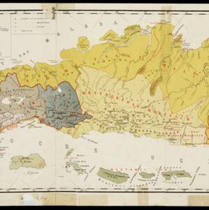
A map of the prevailing languages and dialects of India and its borders
1885
Myanmar, Thailand, Malaysia
A late 19th century map showing the languages and dialects spoken in and around India, including regions of Siam, Burma and Malaya. The regions are colour-coded by language and bordered by red lines to indicate different dialects.
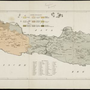
Schets-taalkaart van de residentie Bangka / Schets-taalkaart van den Riouw- en Lingga-archipel
1889
Indonesia
Two separate maps showing the languages and dialects spoken on the islands of Bangka, and the Riouw (Riau) and Lingga archipelagos, in the late 19th century. On Bangka alone, there are 12 languages or dialects listed.


