
Search Results
56 Results found


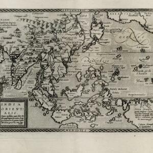
Indiae Orientalis insularumque adiacientium typus
1579
Brunei, Cambodia, East Timor, Indonesia, Laos, Malaysia, Myanmar, Philippines, Singapore, Southeast Asia, Thailand, Vietnam
A red banner at the right features text that notes that the ‘Insule Molucce’ (Maluku Islands) are famous for their abundance of spices, which are sold across the world. There are also Illustrations of mermaids and sea monsters wrecking a ship.
India Orientalis: cuius nobilior pars sunt duo ista quasi ingentia totius Asiæ promontoria in Oceanum versus Meridiem projecta, cum suis insulis
1600
Brunei, Cambodia, East Timor, Laos, Malaysia, Myanmar, Philippines, Singapore, Southeast Asia, Thailand, Vietnam
The island of Java was initially labelled on this map as ‘Iaua Minor’ (Java Minor), but this was altered to ‘Iaua Maior’ (Java Major), reflecting the common confusion over the names at the time. Sumatra and Borneo were both similarly mis-labelled.

Svmatra cum circumiacentibus insulis
1601
Indonesia, Malaysia, Singapore
A colourful early 17th century map of Sumatra, Java and the Malay Peninsula, with North located to the left, and major settlements marked. Latin text on the reverse describes the peoples, religions, languages, agriculture, mining etc. of the region.

Insulæ Indiæ orientalis præcipuæ: in quibus Moluccæ celeberrimæ sunt
1606
Brunei, Cambodia, East Timor, Indonesia, Laos, Malaysia, Myanmar, Philippines, Singapore, Southeast Asia, Thailand, Vietnam
On the right of this map, Latin text held within an elaborate border notes that five of the Maluku Islands are located nearby—Ternate, Tidore, Moti, Makian and Bacan—which trade spices including clove, cinnamon, nutmeg and ginger to the world.


Insulæ Indiæ orientalis præcipuæ: in quibus Moluccæ celeberrimæ sunt
1623
Brunei, Cambodia, East Timor, Indonesia, Laos, Malaysia, Myanmar, Philippines, Singapore, Southeast Asia, Thailand, Vietnam
On the right of this map, Latin text held within an elaborate border notes that five of the Maluku Islands are located nearby—Ternate, Tidore, Moti, Makian and Bacan—which trade spices including clove, cinnamon, nutmeg and ginger to the world.

Molvccae insvlae celeberrimae
c.1640-1655
Indonesia
This small island chain off the west coast of Gilolo (Halmahera in the Maluku Islands, Indonesia), was an important area for the spice trade. Latin text on the reverse describes the trade/islands. North is located to the right, rather than the top.

India quae Orientalis dicitur, et insvlae adiacentes
1664
Brunei, Cambodia, East Timor, Indonesia, Laos, Malaysia, Myanmar, Philippines, Singapore, Southeast Asia, Thailand, Vietnam
French text on the reverse of this map describes the religion, languages, crops, trade etc. of Aracam and Pegu (Myanmar), Siam (Thailand), Cambaja (Cambodia). The map is dedicated to the Dutch merchant Christophoro Thisio.
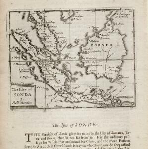
The isles of Sonda
1680
Brunei, Indonesia, Malaysia, Singapore
From Robert Morden’s ‘Geography Rectified’, a description with maps of the known world in the late 17th century. Text describes the peoples of the uplands of the Sunda Islands as ‘Pagans’, while the coastal peoples are ‘Mahumetans [Muslims]’.


Carte des Indes et de la Chine
c.1700
Brunei, Cambodia, East Timor, Indonesia, Laos, Malaysia, Myanmar, Philippines, Singapore, Southeast Asia, Thailand, Vietnam
The regional borders of early 18th century Southeast Asia are shown on this map. Mountains are shown pictorially, and larger settlements are marked with a building symbol. Southern Borneo is labelled ‘Pays des Mahometans [Land of the Muslims]’.


