Search

Search Results

Nova Totius Asiae Tabula

eventc.1750

location_onBrunei, Cambodia, East Timor, Indonesia, Laos, Malaysia, Myanmar, Philippines, Singapore, Southeast Asia, Thailand, Vietnam

This elaborately illustrated map of Asia is decorated with images of angels and cherubs, various figures dressed in colourful robes, wild animals, a procession including elephants and camels, and a double hemisphere world map.

Insulae Iavae pars Occidentalis

event1728

location_onIndonesia

A map of Java with mountains, jungles, animals and crops. Bathymetry (sea depth) is marked, including on an inset map of Batavia harbour. Illustrations include Batavia Castle, and a lion—representing Belgium—receiving tribute and enslaving locals.

Insulae Iavae pars Occidentalis

eventc.1720

location_onIndonesia

A map of west Java with mountains, jungles, animals and crops. Details include sea depth, an inset map of Batavia harbour, and an illustration of a lion—representing Belgium—receiving tribute and enslaving locals. A similar map of east Java was made.

Insulae Iavae Pars Occidentalis / Insulae Iavae Pars Orientalis

eventc.1720

location_onIndonesia

A map of Java with mountains, jungles, animals and crops. Bathymetry (sea depth) is marked, including on an inset map of Batavia harbour. Illustrations include Batavia Castle, and a lion—representing Belgium—receiving tribute and enslaving locals.

L'Asie, selon les nouvelles observations de Messrs. de l'Academie des Sciences

event1713

location_onBrunei, Cambodia, East Timor, Indonesia, Laos, Malaysia, Myanmar, Philippines, Singapore, Southeast Asia, Thailand, Vietnam

This early 18th century map of Asia features a drawing of a woman burning offerings on an altar, while two children carry cornucopias, and a camel looks on. The Roman god Mercury descends from the sky in the background wearing his winged helmet.

Insulae Iavae pars Occidentalis

eventc.1710-1719

location_onIndonesia

A map of Java with mountains, jungles, animals and crops. Bathymetry (sea depth) is marked, including on an inset map of Batavia harbour. Illustrations include Batavia Castle, and a lion—representing Belgium—receiving tribute and enslaving locals.

Asia noviter delineata

event1640

location_onBrunei, Cambodia, East Timor, Indonesia, Laos, Malaysia, Myanmar, Philippines, Singapore, Southeast Asia, Thailand, Vietnam

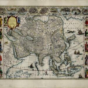
This map is illustrated with drawings of Asian people wearing traditional clothing, including representatives of Sumatra, Java and the Maluku Islands. There are also drawings of important ports such as Bantam (Banten) at the western end of Java.

Asia noviter delineata

eventc.1635-1638

location_onBrunei, Cambodia, East Timor, Indonesia, Laos, Malaysia, Myanmar, Philippines, Singapore, Southeast Asia, Thailand, Vietnam

This map is illustrated with drawings of Asian people wearing traditional clothing, including representatives of Sumatra, Java and the Maluku Islands. There are also drawings of important ports such as Bantam (Banten) at the western end of Java.

Asia noviter delineata

event1630

location_onBrunei, Cambodia, East Timor, Indonesia, Laos, Malaysia, Myanmar, Philippines, Singapore, Southeast Asia, Thailand, Vietnam

This map is illustrated with drawings of Asian people wearing traditional clothing, including representatives of Sumatra, Java and the Maluku Islands. There are also drawings of important ports such as Bantam (Banten) at the western end of Java.

close