
Search Results


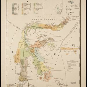
Topographische kaart der residentie Soerabaja
1895
Indonesia
The residency of Soerabaja, East Java, featuring crops (coffee, coconut, sugarcane, rice, alang-alang, bamboo) and fishing ponds. Three inset maps: a triangulation map; a map of distances between settlements by types of transport; Bawean Island.

Topographische kaart van het eiland Billiton: vluchtig opgenomen in de jaren 1877-1878
1894
Indonesia
This map of the island of Billiton (Belitung, Indonesia) features mountains, rivers, railways, roads, settlements, coconut plantations and administrative borders. An inset map shows the island’s port and capital city Tanjung Pandan.


Topographische kaart van de residentie Preanger regentschappen
1894
Indonesia
The residency of Preanger (Parahyangan), West Java, with plantations (coconut, coffee, tea, cinchona (‘kina’), betel, teakwood, bamboo) and crops (rice, sugarcane, alang-alang). Two inset maps: a triangulation map, and a map of land route distances.


A map of British North Borneo
1894
Malaysia, Brunei, Indonesia
The colonial territories of British North Borneo are shown in pink on this late 19th century map, with Brunei and Sarawak in green, and Dutch colonial territory in yellow. Sea routes around the British Empire are depicted on an inset map.


Trade Routes in the Far East
1894
Brunei, Cambodia, Indonesia, Laos, Malaysia, Myanmar, Philippines, Singapore, Thailand, Vietnam
Map of stream ship trade routes around Southeast Asia. Rivers, railways, submarine telegraph cables, lighthouses (fixed, revolving and flashing), graving docks and coaling stations are marked. An inset map shows a railway route from Britain to Asia.
- Filter from 1630 to 1900
- Dutch159
- English84
- German36
- French31
- Latin26
- Italian3
- Hindi1
- Portuguese1
- more Language »
- [remove]Inset Map330
- Legend176
- Illustration67
- Elevation49
- Cartouche44
- Coat of Arms22


