Search

Search Results

Military map of the Isle of Luzon

event1900

location_onPhilippines

A map of Luzon, Philippines divided into military and civilian regions. Made for the American military, it features roads, railways, telegraph lines, mountains and rivers. An inset map of Manila shows military, civil and religious buildings.

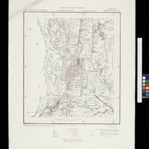
Military district no. 1: Department of northern Luzon

event1900

location_onPhilippines

A map of the northwest coastal region of Luzon, Philippines made for the American military during the Philippine–American War (1899–1902). The area is divided into provinces, and major roads, settlements, mountains and rivers are marked.

Island of Luzon

event1900

location_onPhilippines

This map of part of the Philippine island of Luzon was compiled during the Philippine–American War (1899–1902), and is marked with routes (paths, wagon roads), land types (grass, woods, swamp) and crops (rice, coconuts, nipa palm, cane sugar, corn).

Burma-China Boundary Commission

event1900

location_onMyanmar

A topographic map of the Burma-China border spread over five sheets. High points are marked with their heights so they can be used for triangulation. Settlements, rivers, trade routes and footpaths are also shown.

Burma-China Boundary Commission: Reconnaissance map. Southern party

event1900

location_onMyanmar

A topographic reconnaissance map of the Burma-China border. High points are marked with their heights so they can be used for triangulation. Settlements, rivers, trade routes and footpaths are also shown.

Burma

event1899

location_onMyanmar

A large-scale topographical map of the states of Hsipaw, Lawksawk and Mongkung, within the Shan State of Burma (Myanmar). Elevation is indicated by contour lines, and travel and trade routes, villages, areas of cultivation and markets are also shown.

Military map of the Isle of Luzon

event1898

location_onPhilippines

A map of southern Luzon, Philippines divided into military and civilian regions. Made for the American military just before the Philippine–American War (1899–1902), it features settlements, roads, railways, telegraph stations, mountains and rivers.

Map of the Island of Singapore and its dependencies

event1898

location_onSingapore

Map of Singapore Island, divided into Districts, including the surrounding islands and straits. The city centre, roads and forests are marked. MacRitchie Reservoir is at the centre of the island, with coconut plantations along the east coast.

A map of the Malay Peninsula

event1898

location_onMalaysia, Singapore, Thailand

Map of the Malay Peninsula showcasing the Straits Settlements in pink, the Federated Malay States in red, and Siamese states in yellow. A table of common words in English, Malay and Siamese is included. Only four of six sheets are available.

A Map of the Malay Peninsula

event1897

location_onIndonesia, Malaysia, Singapore, Thailand

On this late 19th century map of the Malay Peninsula, the British colonial territories—the Straits Settlements of Singapore, Malacca, Dinding and Penang—are in red, demarcating them from the British protectorate states of the rest of the peninsula.

British New Guinea: Sketch plan showing the route traversed by His Excellency Sir Wm. Macgregor... from the Mambre mouth to the village of Gosisi on the Vanapa

event1897

location_onPapua New Guinea

Map of the Mambare River from Mount Victoria to the sea at Duvira (or Traitors) Bay, British New Guinea. Villages, bases, camps and stores are marked, and there are notes on terrain (‘Low Hills’), vegetation (‘Betal Palms’), river width, rapids etc.

City of Mandalay and environs

event1894

location_onMyanmar

Map of the Burmese city of Mandalay on the Irrawaddy River. The city has a grid of roads and buildings, dominated by Fort Dufferin (formerly Mandalay Palace). The surrounding country has villages, crops, agricultural ponds and irrigation channels.

close