
Search Results
16 Results found


Kaart van het gebied bezet in Groot-Atjeh, met de nederzettingen Lepoeng en Lehoeng
1897
Indonesia
A map of Groot-Atjeh, Lepoeng and Lehoeng, at the northern tip of Sumatra, detailing routes (rivers, roads, railways), crops (rice, banana, sugarcane, betel, pepper, alang-alang, bamboo) and land features (forests, mountains, wetlands).

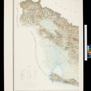
Atlas van Nederlandsch Oost-Indië
c.1897-1904
Indonesia
Very detailed atlas of the entire Dutch East Indies, over 16 map sheets, with a cover and overview map. Includes topographic maps, inset maps of cities and islands, and maps featuring land and sea routes, languages, geology, colonial territory etc.

Kaart van het gebied bezet in Groot-Atjeh, met de nederzettingen Lepoeng en Lehoeng
1897
Indonesia
A map of Groot-Atjeh, Lepoeng and Lehoeng, at the northern tip of Sumatra, detailing routes (rivers, roads, railways), crops (rice, banana, sugarcane, betel, pepper, alang-alang, bamboo) and land features (forests, mountains, wetlands).

Topographische Kaart der residentie Batavia
1897
Indonesia
The residency of Batavia, West Java, featuring plantations (coffee, tea, coconut, cinnamon, nutmeg, sugar); crops (rice, alang-alang, bamboo); fishing ponds; factories, warehouses, shops; routes, administrative borders; mountains, rivers, lakes.

Topographische kaart der residentie Soerabaja
1895
Indonesia
The residency of Soerabaja, East Java, featuring crops (coffee, coconut, sugarcane, rice, alang-alang, bamboo) and fishing ponds. Three inset maps: a triangulation map; a map of distances between settlements by types of transport; Bawean Island.

Topographische kaart van de residentie Preanger regentschappen
1894
Indonesia
The residency of Preanger (Parahyangan), West Java, with plantations (coconut, coffee, tea, cinchona (‘kina’), betel, teakwood, bamboo) and crops (rice, sugarcane, alang-alang). Two inset maps: a triangulation map, and a map of land route distances.

Topographische kaart der residentie Pasoeroean
1887
Indonesia
The residency of Pasoeroean (Pasuruan), East Java, featuring crops (coffee, cinchona (kina), rice, alang-alang, bamboo) and fishing ponds. Two inset maps: a triangulation map, and a map of distances between settlements by various types of transport.

Topographische kaart der residentie Soerabaja
1884
Indonesia
The residency of Soerabaja, East Java, featuring crops (coffee, coconut, sugarcane, rice, alang-alang, bamboo) and fishing ponds. Three inset maps: a triangulation map; a map of distances between settlements by types of transport; Bawean Island.

Topographische kaart der residentie Batavia
c.1882-1883
Indonesia
The residency of Batavia, West Java, featuring plantations (coffee, tea, coconut, cinnamon, nutmeg, sugar); crops (rice, alang-alang, bamboo); fishing ponds; factories, warehouses, shops; routes, administrative borders; mountains, rivers, lakes.

Kaart van het terrein des oorlogs in Groot-Atjeh
1883
Indonesia
The Aceh War (1873–1904) between the Sultanate of Aceh and Dutch colonists is highlighted on this map of Groot-Atjeh in 1876. Flag symbols mark the locations of Dutch military posts, and some villages are described as ‘verbrande [burnt]’.
- Filter from 1865 to 1898
- Dutch16
- [remove]Kampong/Village16
- [remove]Residential Area16
- Post Office10
- Cemetery/Columbarium8
- Military Fort6
- Military Barracks5
- Church2
- Court of Law2
- Hospital2
- Jail/Prison2
- Mosque2
- Well2
- Palace1
- Police Station1
- more Settlement Features »
- [remove]Railway/Tramway16
- [remove]Road16
- Path15
- River14
- Postal Route11
- Canal7
- Telegraph/Telephone4
- Bridge2


