
Search Results


Azië : 1861
1861
Brunei, Cambodia, East Timor, Indonesia, Laos, Malaysia, Myanmar, Papua New Guinea, Philippines, Singapore, Southeast Asia, Thailand, Vietnam
Map of Asia published by the North Holland Regional Association of the Dutch Teachers' Association. Mainland Southeast Asia is labelled ‘Achter Indie [Beyond India]’; the Indonesian Archipelago is labelled ‘Indische Archipel [Indian Archipelago]’.

Oostindië
1842
Brunei, Cambodia, East Timor, Indonesia, Laos, Malaysia, Myanmar, Philippines, Singapore, Southeast Asia, Thailand, Vietnam
Dutch map of the East Indies, with mountain ranges represented by simple hachure marks, and just a few rivers marked. Mainland Southeast Asia is labelled ‘Achter Indie [Beyond India]’.

Kaart van Azië ten gebruike der scholen van het Koninkrijk der Nederlanden = Carte d'Asie, a l'usage des maisons d'éducation
1830
Brunei, Cambodia, East Timor, Indonesia, Laos, Malaysia, Myanmar, Philippines, Singapore, Southeast Asia, Thailand, Vietnam
Map of Asia spread over nine sheets, for use in schools. Place names are not printed on the map itself, but are represented by initials and numbers (presumably, there is a legend that lists the names, but it is not present).

Kaart van Oost Indiën: behoorende bij Olivier Land- en zeetogten
1830
Brunei, Cambodia, East Timor, Indonesia, Laos, Malaysia, Myanmar, Philippines, Singapore, Southeast Asia, Thailand, Vietnam
Map from Johannes Olivier’s book ‘Land- en Zeetogten in Nederland's Indie [Land and Sea Journeys in the Dutch Indies]’, showing European colonial possessions and indigenous kingdoms in Asia.
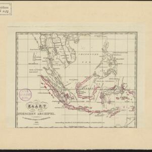
Kaart van den Indischen Archipel
1830
Brunei, Cambodia, East Timor, Indonesia, Laos, Malaysia, Myanmar, Philippines, Singapore, Southeast Asia, Thailand, Vietnam
This map shows the Dutch colonial possessions or dependencies in the East Indies during the early 19th century. Areas not coloured red remained under local rulers or were colonies of other European powers.
Kaart van Azië ten gebruike der scholen van het Koninkrijk der Nederlanden = Carte d'Asie, a l'usage des maisons d'éducation
1830
Brunei, Cambodia, East Timor, Indonesia, Laos, Malaysia, Myanmar, Philippines, Singapore, Southeast Asia, Thailand, Vietnam
Map of Asia spread over nine sheets, for use in schools. Place names are not printed on the map itself, but are represented by initials and numbers (presumably, there is a legend that lists the names, but it is not present).
Kaart van Oost Indiën: behoorende bij Olivier Land- en zeetogten
1830
Brunei, Cambodia, East Timor, Indonesia, Laos, Malaysia, Myanmar, Philippines, Singapore, Southeast Asia, Thailand, Vietnam
Map from Johannes Olivier’s book ‘Land- en Zeetogten in Nederland's Indie [Land and Sea Journeys in the Dutch Indies]’, showing European colonial possessions and indigenous kingdoms in Asia.
Kaart van den Indischen Archipel
1830
Brunei, Cambodia, East Timor, Indonesia, Laos, Malaysia, Myanmar, Philippines, Singapore, Southeast Asia, Thailand, Vietnam
This map shows the Dutch colonial possessions or dependencies in the East Indies during the early 19th century. Areas not coloured red remained under local rulers or were colonies of other European powers.


