
Search Results


Carte générale des possessions néerlandaises aux Indes orientales
1846
Brunei, East Timor, Indonesia, Malaysia, Philippines, Singapore
Map of the Asian colonial possessions of the Netherlands (Dutch East Indies), with an inset of the heights of some of the region’s mountains. A note describes the average temperature, barometer reading and magnetic declination in Batavia at the time.

Kaart der Nederlandsche bezittingen in Oostindien = Possessions hollanaises aux Indes Orientales
1840
Brunei, East Timor, Indonesia, Malaysia, Singapore
Map of Dutch colonial territory in Southeast Asia, including the administrative areas of Java and Madura. Two maritime routes are marked from Batavia to the Maluku Islands: of the brig ‘Douga’ in 1825, and by Baron Godert van der Capellen in 1824.
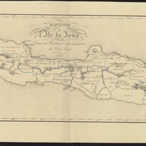
Esquisse de l'ile de Java: divisée en Residences avec indication des chefs-lieux
1833
Indonesia
Map of Java divided into Dutch administrative areas (‘residencies’), and the Empire of Soerakarta and Kingdom of Djokjakarta, which were under indigenous rule (a note records the territories these indigenous areas lost in the Java War (1825–1830)).


