Search

Search Results

Ins: Macjan, Ins: Bactjan

eventc.1631-1657

location_onIndonesia

These pages are probably from ‘Newe Welt und Americanische Historien’ by Johann Gottfried. There are maps of Pulau Makian (‘Ins. Macjan’) and Pulau Bacan (Ins. Bacjan) in the Maluku Islands, and a plan of a fort on Makian.

Solor

eventc.1631-1657

location_onIndonesia

From Ludwig Johann Gottfried’s ‘Newe welt und Americanishe historien’, a drawing of warships—probably Dutch and Portuguese—fighting in the harbour of the volcanic island of Solor (Lesser Sunda Islands). German text describes the region.

Contrafactur des Scharmutz els der Hollander wider die Portigesen in dem Flus Batusabar

event1607

location_onSingapore

Maps can sometimes record a single event: this map depicts an October 1603 battle between the Dutch and Portuguese, as they fought for control of the trade routes through the Singapore Straits. The text panel recounts the story of the battle.

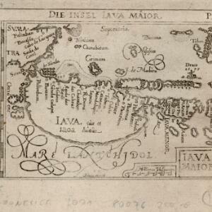
Descriptio hydrographica accommodata ad battavorum navagatione in Javam insulam Indiæ Orientalis

eventc.1599-1628

location_onBrunei, Cambodia, East Timor, Indonesia, Laos, Malaysia, Myanmar, Philippines, Singapore, Southeast Asia, Thailand, Vietnam

This map shows the route of the first Dutch expedition to Southeast Asia in 1595-7. Led by Cornelis de Houtman, it was an attempt to enter the spice trade. The route crosses east over the Indian Ocean, circles the island of Java, and returns west.

Iava Maior

eventc.1590-1650

location_onIndonesia

The line of settlements along the north coast of Java—contrasting with the almost empty interior—show that this map’s focus is on the sea. The islands, shoals and reefs that are marked, and the drawings of ships, reinforce this idea.

close

  • Filter from 1590 to 1631

Current results range from 1590 to 1631