
Search Results


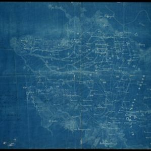
Kaiser Wilhelms-Land: Das Hinterland der Astrolabe-Bucht bis zum Ramu-Fluss
1896
Papua New Guinea
Map of part of the north coast of Kaiser-Wilhelmsland (German New Guinea) spread over two sheets. It focuses on rivers, noting width, depth, temperature, currents, vegetation etc.; and on mountains, showing heights and side views (elevations).

Schutzgebiet der Neu-Guinea-Kompanie
c.1892-1893
Indonesia, Papua New Guinea
Very detailed six-sheet map of eastern New Guinea, with numerous inset maps of bays and islands, and other inset maps covering ethnography, explorers of the region, marine routes across the Pacific Ocean, cannibalism, missionaries activity etc.

Übersichtskarte der Französischen Expedition in Hinterindien vom Me-khong bis zum Jang-tse-kiang
1869
Myanmar, Thailand, Vietnam, Laos
This map of the border region between China, Birma (Myanmar), Siam (Thailand and Laos) and Anam (Vietnam) is marked with the routes of five expeditions of the region from 1837 to 1868. Locations of Roman Catholic missionaries are also shown.

General-Karte von Mittleren Sumatra von Padang bis Singkel
1847
Indonesia
This map focuses on the mountain ranges along the west coast of central Sumatra. Military bases, post offices, villages, rivers and hot springs are also marked, and there are inset maps of the towns of Padang and Singkel (Singkil).


Der Hollaendisch-Ostindianischen Compagnie weltberühmte Haupt-Handels und Niederlags: Stadt Batavia
1747
Indonesia
The legend and written notes on this plan of Batavia (Jakarta) provide much detailed information about the important port city in the early 18th century. It is also beautifully decorated with paintings of the city, local people, animals and ships.

Der Hollaendisch-Ostindianischen Compagnie weltberühmte Haupt-Handels und Niederlags: Stadt Batavia
1733
Indonesia
The legend and written notes on this plan of Batavia (Jakarta) provide much detailed information about the important port city in the early 18th century. It is also beautifully decorated with paintings of the city, local people, animals and ships.


Sumatra ein grosse Insel: so von den alten Geographen Taprobana genennet worden
c.1588-1628
Indonesia, Malaysia, Singapore, Thailand
A map of Sumatra featuring villages, mountains and rivers; text describing the island; and a drawing of a man riding an elephant. The title uses the name ‘Taprobana’ for Sumatra, stating it was a name used by ‘ancient geographers [alten geographen]’.


