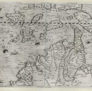
Search

Search Results

Asia

event1598

location_onBrunei, Cambodia, East Timor, Indonesia, Laos, Malaysia, Myanmar, Philippines, Singapore, Southeast Asia, Thailand, Vietnam

This late 16th century map features a 'wind-head', a decorative feature consisting of a drawing of the head of a human blowing to indicate wind.

Sumatra

event1565

location_onIndonesia

This early map of Sumatra (labelled ‘Taprobana’) features many illustrations. In the sea, there are ships, fish and sea monsters, while on land, plantations, agricultural workers, a shepherd and wooden buildings highlight the economy of the island.

Sumatra

event1565

location_onIndonesia

This early map of Sumatra (labelled ‘Taprobana’) features many illustrations. In the sea, there are ships, fish and sea monsters, while on land, plantations, agricultural workers, a shepherd and wooden buildings highlight the economy of the island.

Sumatra

event1565

location_onIndonesia

This early map of Sumatra (labelled ‘Taprobana’) features many illustrations. In the sea, there are ships, fish and sea monsters, while on land, plantations, agricultural workers, a shepherd and wooden buildings highlight the economy of the island.

Terza Tavola

event1565

location_onBrunei, Cambodia, East Timor, Indonesia, Laos, Malaysia, Myanmar, Philippines, Singapore, Southeast Asia, Thailand, Vietnam

South is orientated towards the top of this map, with maritime Southeast Asia in the upper half and the mainland below. Top right is Java (‘Iava Magiore [Java Major]’); Borneo is labelled ‘Iava Menore [Java Minor]’. Ships and sea monsters are at sea.

Sumatra

event1565

location_onIndonesia

This early map of Sumatra (labelled ‘Taprobana’) features many illustrations. In the sea, there are ships, fish and sea monsters, while on land, plantations, agricultural workers, a shepherd and wooden buildings highlight the economy of the island.

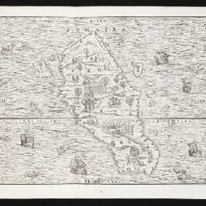
India tercera nvova tavola

event1561

location_onCambodia, Indonesia, Laos, Malaysia, Myanmar, Philippines, Singapore, Southeast Asia, Thailand, Vietnam, Brunei

This mid-16th century map of Southeast Asia shows some inaccuracies, especially in the shape of the Malay Peninsula and the islands meant to represent Sumatra (labelled ‘Camatra’), Java (‘Iava Mazor’) and Borneo (‘Iava Menor’). Latin text on reverse.

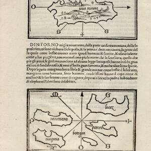
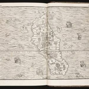
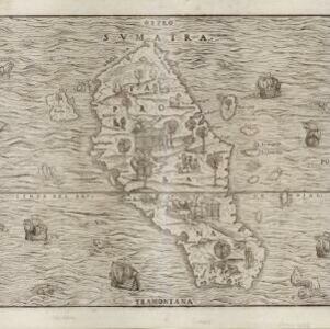
[Java Minor and map of Necumera, Locaz, Patera, Botegon, Mangama]

event1547

location_onThailand, Indonesia

Taken from Benedetto Bordone's ‘Isolario [The Book of Islands]’, these pages contain two maps: one of Sumatra (‘Iaua Minore’), and one of a group of five unknown islands (Locaz is thought to possibly be Thailand).

close

  • Filter from 1547 to 1799

Current results range from 1547 to 1799