
Search Results
4 Results found

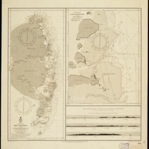
Oostkust: Aroe-Eilanden / Ankerplaats voor Watoelei en Koemoel
1896
Indonesia
Map of the east coast of the Aru Islands (Maluku Islands), with bathymetry (sea depth), tides and currents, shoals and other obstructions. An inset map shows the anchorage at islands off the coast, along with elevation views of the islands.

Vaarwaters en ankerplaatsen op de oostkust der Aroe-eilanden
1896
Indonesia
Four navigation maps of the waterways and anchorages around the east coast of the Aru Islands (in the Maluku Islands, near New Guinea). Bathymetry (sea depth), shoals and other obstructions are shown, with trees and villages to use as landmarks.
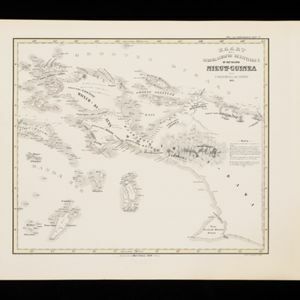
Kaart der Nederlandsche Bezittingen of het Eiland Nieuw-Guinea
1853
Indonesia
Map of Dutch colonial territory in New Guinea and nearby islands, featuring the 1850 route of the Dutch schooner Circe under Lieutenant Brutel de la Rivière. (From ‘Algemeene Atlas van Nederlandsche Indie [General Atlas of the Dutch East Indies]’.)


