
Search Results
14 Results found


An Accurate Map of Asia
1783
Brunei, Cambodia, East Timor, Indonesia, Laos, Malaysia, Myanmar, Philippines, Singapore, Southeast Asia, Thailand, Vietnam
From the first volume of John Seally’s ‘A Complete Geographical Dictionary’, this map of Asia includes the ancient kingdoms of mainland Southeast Asia, and the Sunda and Molucca islands (‘Molucca or Spice Islands’) of maritime Southeast Asia.

Nieuwe generale kaart van Asia: Volgens de laatste ontdekkingen van Cook
c.1780
Brunei, Cambodia, East Timor, Indonesia, Laos, Malaysia, Myanmar, Philippines, Singapore, Southeast Asia, Thailand, Vietnam
Map of Asia based—according to the subtitle—on discoveries by the British Royal Navy captain James Cook. It includes Batavia (Jakarta) where he visited in 1770, and the South China Sea through which his ship Resolution sailed after his death in 1779.

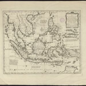
Nieuwe en Naukeurige Kaart der Oost-Indische Eilanden
1774
Brunei, Cambodia, East Timor, Indonesia, Laos, Malaysia, Myanmar, Philippines, Singapore, Southeast Asia, Thailand, Vietnam
Some regions on this map of Southeast have a descriptive label: New Guinea is described as unknown to Europeans; Borneo was abandoned by Europeans due to the ‘unmanageability’ of the inhabitants; the Philippines were discovered by Spain in 1565.

Nieuwe en naukeurige kaart van Asia
1773
Indonesia, Brunei, Cambodia, East Timor, Laos, Malaysia, Myanmar, Papua New Guinea, Philippines, Singapore, Southeast Asia, Thailand, Vietnam
Map of Asia featuring an early—and very vague—depiction of New Britain (‘Nieuw Brittanje’) which was named by the British explorer William Dampier when he visited in 1700. The ‘Straat van Dampier’ is also shown, dividing New Britain from New Guinea.
Nieuwe en naukeurige kaart der Oost-Indische Eilanden
c.1770
Brunei, Cambodia, East Timor, Indonesia, Laos, Malaysia, Myanmar, Philippines, Singapore, Southeast Asia, Thailand, Vietnam
Some regions on this map of Southeast have a descriptive label: Sumatra is described as having mines of gold, silver, iron, and sulphur; and elephants, tigers, rhinoceroses, dragons and crocodiles. Gilolo has rice, sago and turtles. Ambon has nutmeg.

Nieuwe kaart van Asia volgens de laatste ontdekkingen
1764
Brunei, Cambodia, East Timor, Indonesia, Laos, Malaysia, Myanmar, Philippines, Singapore, Southeast Asia, Thailand, Vietnam
Map of Asia divided into large colour-coded regions: the western half of mainland Southeast Asia is joined with India (‘Indien’), and coloured red; the eastern half is joined with China, all in yellow.
- Filter from 1724 to 1795
- Brunei14
- Cambodia14
- East Timor14
- Indonesia14
- Laos14
- Malaysia14
- Myanmar14
- Philippines14
- Singapore14
- [remove]Southeast Asia14
- Thailand14
- Vietnam14
- more Simple Location »
- [remove]Ava14
- Java14
- [remove]Siam14
- Sumatra14
- [remove]Sunda Islands14
- [remove]Western New Guinea14
- Borneo13
- Malay Peninsula13
- Maluku Islands13
- Celebes12
- Sulawesi12
- Cochin China10
- more Detailed Location »


