
Search Results


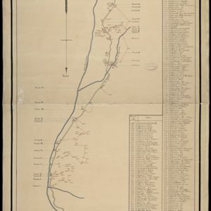
Overzichtskaart en bladwijzer van de residentie Kediri
1893
Indonesia
This overview map of the residency of Kediri (East Java, Indonesia) features roads, railways and paths. It is divided into five regencies, which are subdivided into 28 districts, which are numbered and listed. Major settlements are also marked.


Kaart van Nederlandsch-Indie
1893
Brunei, Cambodia, Indonesia, Malaysia, Singapore, Thailand, Vietnam, East Timor, Philippines, Southeast Asia
Shipping routes are the focus of this map of the Dutch East Indies, indicated by red lines labelled with the name of the shipping company and the destinations. Parcel shipping routes are also shown. Inset maps feature railway lines too.


Kaart van de dichtheid van bevolking van Java en Madoera
1892
Indonesia
This map shows the population density of Java and Madura in 1892. The area is divided into regencies, which are then subdivided into districts, with the districts shaded to represent its population. Each district is also listed under its regency.

Kaart van den gemiddelden regenval op Java, tevens situatie-schets van de djati- en wildhoutbosschen
1892
Indonesia
This late 19th century map records the average rainfall at a variety of locations—marked with blue dots—on Java. Three types of forest are also shown: cultivated forest, wild forest under management, and wild forest not under management.

Kaart van den op Java en Madoera reeds in gebruik genomen grond
1892
Indonesia
Land usage statistics are shown on this map of Java and Madura. The amount of land used in each district is indicated by green hash marks, and by a number giving its land use percentage. District names are listed and identified by a letter.

Topographische kaart der residentie Djokjakarta
1892
Indonesia
The residency of Djokjakarta (Yogyakarta), southern Java, featuring crops (coffee, sugar, rice, alang-alang, tobacco, indigo plants, nipa palm, bamboo); warehouses, cemeteries, post offices; routes, administrative borders; mountains, rivers.

Topographische Kaart der residentie Pekalongan
1892
Indonesia
Topographic map of the residency of Pekalongan (Central Java), divided into regencies (pink borders) and districts (yellow borders). Mountains, forests, settlements, routes, crops—alang-alang, coffee, sugar, rice—factories and warehouses are shown.

- Filter from 1535 to 1900
- Dutch321
- French179
- Latin171
- English154
- German62
- Italian21
- Spanish2
- Portuguese1
- more Language »
- Indonesia845
- Malaysia563
- Singapore550
- Brunei537
- East Timor510
- Philippines506
- Thailand494
- Cambodia492
- Vietnam485
- Southeast Asia467
- Myanmar461
- Laos457
- more Simple Location »
- [remove]Java846
- Sumatra600
- Borneo567
- Sulawesi471
- Malay Peninsula429
- Celebes402
- Western New Guinea319
- Maluku Islands309
- Siam262
- Sunda Islands247
- Dutch East Indies235
- Malacca212
- more Detailed Location »
- Port124
- Pier64
- Railway Station29
- River582
- Road173
- Path90
- Postal Route88
- Railway/Tramway63
- Canal61
- Bridge24
- Telegraph/Telephone20


