
Search Results


Atlas van Nederlandsch Oost-Indië
c.1897-1904
Indonesia
Very detailed atlas of the entire Dutch East Indies, over 16 map sheets, with a cover and overview map. Includes topographic maps, inset maps of cities and islands, and maps featuring land and sea routes, languages, geology, colonial territory etc.

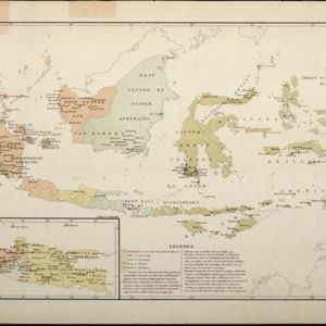
Kaart van den Nederlandsch Oost Indischen archipel aantoonende de door de Inlandsche bevolking beleden godsdiensten
1896
Indonesia
A map of the religions of the local peoples of the Dutch East Indies, with areas marked as Christian, Muslim, ‘heathen’. With population figures, including for Protestants and Catholics, and locations of missionaries and other religious teachers.

Kaart aangevende den bestaande toestand met betrekking tot het rechtswezen in Ned. Indië
1883
Indonesia
This map highlights the judicial system in the Dutch East Indies (‘Nederlands-Indië’) in the late 19th century. Different colours indicate the areas of authority of the different courts of law. There is an inset map of Java.

Kaart van Zuid West Celebes, bevattende de Gouvernements en Bondgenootschappelijke Landen van het Gouvernement Celebes
1860
Indonesia
Map of the South Peninsula of Celebes (Sulawesi). The Spermonde Archipelago in the Makassar Strait is very detailed with islands, shoals, reefs and bathymetry. (From ‘Algemeene Atlas van Nederlandsche Indie [General Atlas of the Dutch East Indies]’.)


Algemeene Kaart van het Gouvernement der Moluksche Eilanden
1855
Indonesia
Map of the Dutch colonial administrative regions (residencies) of the Moluccas (Maluku Islands), with Celebes (Sulawesi) and New Guinea. (From ‘Algemeene Atlas van Nederlandsche Indie [General Atlas of the Dutch East Indies]’.)

Kaart van Noord & Oost-Celebes, bevattende gedeelton der residentien Manado en Ternate
1854
Indonesia
Map of northern and eastern Celebes (Sulawesi) colour-coded by administrative region: the residencies of Manado (red borders) and Ternate (yellow borders). (From ‘Algemeene Atlas van Nederlandsche Indie [General Atlas of the Dutch East Indies]’.)

Algemeene Atlas van Nederlandsche Indie
c.1853-1862
Indonesia
Atlas featuring over 60 detailed maps of the Dutch East Indies: 24 maps cover Java; the remainder cover the rest of the Dutch East Indies. There are three index maps. (All the maps in this atlas are also presented separately on this platform.)

Kaart van de Minahassa in de Residentie Manado
1853
Indonesia
Map of part of the Dutch colonial administrative region of Manado, on the Minahasa Peninsula, Celebes (Sulawesi). Includes an elevation view of the mountains. (From ‘Algemeene Atlas van Nederlandsche Indie [General Atlas of the Dutch East Indies]’.)

Exactissima Asiae delineatio, in praecipuas regiones, ceterasq partes divisa
1705
Brunei, Cambodia, East Timor, Indonesia, Laos, Myanmar, Malaysia, Philippines, Singapore, Southeast Asia, Thailand, Vietnam
The illustration on this map highlights the wealth of the Asian trade routes, with merchants wearing colourful and elaborate robes presenting valuable treasures to a royal figure. A monkey, tortoise and camel emphasise the 'exoticism' of Asia.


