
Search Results
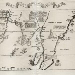
Tabv moder Indiae
1535
Cambodia, Indonesia, Malaysia, Myanmar, Thailand, Vietnam
Early map of Asia, with the islands of Taprobana (Sumatra) to the west of the Malay Peninsula, and Timonia (Tioman) to the east. Text gives details of local economies: sandalwood on Tioman, and silver and silk at Lamai near Mallaqua (Malacca).

India extrema, XIX nova tabvla
1540
Brunei, Cambodia, East Timor, Indonesia, Laos, Malaysia, Myanmar, Philippines, Singapore, Southeast Asia, Thailand, Vietnam
This 1540 map by the German cartographer Sebastian Münster (1488–1552) was based on the work of the 2nd century geographer Ptolemy. On the reverse, there is Latin text giving details of the area, including crops grown.
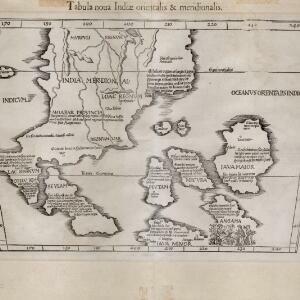
Tabula noua Indiæ orientalis & meridionalis
1541
Malaysia, Indonesia, Southeast Asia
This early map of Asia includes text describing the local people, their religious beliefs, crops, spices etc. On the island labelled Angama there is a drawing of anthropophagi—members of a mythical race of cannibals—chopping up a human body.
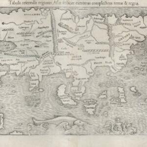
Tabula orientalis regionis, Asiae scilicet extremas complectens terras et regna
1545
Brunei, Cambodia, East Timor, Indonesia, Laos, Malaysia, Myanmar, Philippines, Singapore, Southeast Asia, Thailand, Vietnam
This 1550 map by the German cartographer Sebastian Münster (1488–1552) was based on the work of the 2nd century geographer Ptolemy. There are many inaccuracies, especially in scale and the locations of mountain ranges, but the region is recognisable.
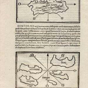
[Java Minor and map of Necumera, Locaz, Patera, Botegon, Mangama]
1547
Thailand, Indonesia
Taken from Benedetto Bordone's ‘Isolario [The Book of Islands]’, these pages contain two maps: one of Sumatra (‘Iaua Minore’), and one of a group of five unknown islands (Locaz is thought to possibly be Thailand).
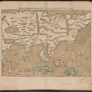
Die Laender Asie nach ihrer Gelegenheit biss in Indiam, werden in dieser Tafeln verzeichnet
1550
Cambodia, Indonesia, Laos, Malaysia, Philippines, Southeast Asia, Thailand, Vietnam, Myanmar, Brunei, East Timor, Singapore
This 1550 map by the German cartographer Sebastian Münster (1488–1552) was based on the work of the 2nd century geographer Ptolemy. There are many inaccuracies, especially in scale and the locations of mountain ranges, but the region is recognisable.
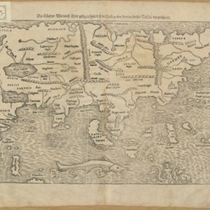
Die Laender Asie nach ihrer Gelegenheit biss in Indiam, werden in dieser Tafeln verzeichnet
c.1550
Brunei, Cambodia, East Timor, Indonesia, Laos, Malaysia, Myanmar, Philippines, Singapore, Southeast Asia, Thailand, Vietnam
This 1550 map by the German cartographer Sebastian Münster (1488–1552) was based on the work of the 2nd century geographer Ptolemy. There are many inaccuracies, especially in scale and the locations of mountain ranges, but the region is recognisable.
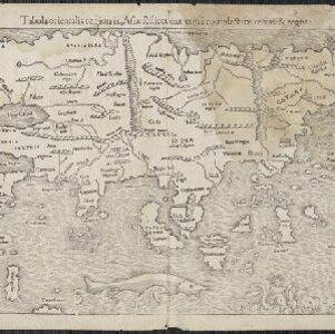
Tabula orientalis regionis, Asiae scilicet extremas complectens terras et regna
1550
Brunei, Cambodia, East Timor, Indonesia, Laos, Malaysia, Myanmar, Philippines, Singapore, Southeast Asia, Thailand, Vietnam
This 1550 map by the German cartographer Sebastian Münster (1488–1552) was based on the work of the 2nd century geographer Ptolemy. There are many inaccuracies, especially in scale and the locations of mountain ranges, but the region is recognisable.

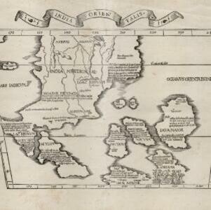
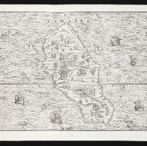
India tercera nvova tavola
1561
Cambodia, Indonesia, Laos, Malaysia, Myanmar, Philippines, Singapore, Southeast Asia, Thailand, Vietnam, Brunei
This mid-16th century map of Southeast Asia shows some inaccuracies, especially in the shape of the Malay Peninsula and the islands meant to represent Sumatra (labelled ‘Camatra’), Java (‘Iava Mazor’) and Borneo (‘Iava Menor’). Latin text on reverse.

- Filter from 1535 to 1900
- Dutch248
- French201
- Latin183
- English170
- German76
- Italian27
- Spanish2
- Portuguese1
- more Language »
- Indonesia839
- Malaysia670
- Singapore644
- Thailand591
- Brunei590
- Cambodia567
- Vietnam553
- Myanmar551
- Philippines543
- Laos525
- East Timor513
- Southeast Asia501
- more Simple Location »
- [remove]Sumatra843
- Borneo614
- Java600
- Malay Peninsula514
- Sulawesi483
- Celebes411
- Western New Guinea328
- Maluku Islands313
- Siam308
- Sunda Islands252
- Malacca241
- Pegu226
- more Detailed Location »


