
Search Results


Map of the Kingdom of Siam and its dependencies
1888
Cambodia, Laos, Malaysia, Myanmar, Thailand, Vietnam
Map of the Kingdom of Siam, featuring mountains, rivers and villages, and surrounded by a yellow border (the border with Upper Burma and China in the north is undefined). The southern part of Siam is shown on an inset map of the Malay Peninsula.


Malay, or East Indian Archipelago, with Burmah, Siam &c.
1887
Brunei, Cambodia, East Timor, Indonesia, Laos, Malaysia, Myanmar, Philippines, Singapore, Southeast Asia, Thailand, Vietnam
On this map of Southeast Asia, numerous small islands, shoals and reefs are marked and named, especially in the South China Sea and around the Sunda and Maluku islands. Submarine cables to carry telegraph messages around the region are also shown.
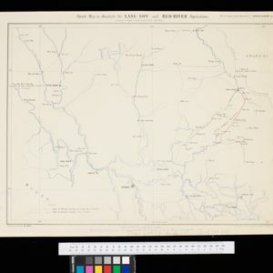
Sketch map to illustrate the Lang-son and Red River operations
1886
Vietnam
Map of the French military advance on the city of Lang-Son in February 1885 during the Sino-French War, and the following month’s humiliating retreat which brought an end to the war, and triggered the collapse of the French government.

Plan topographique de l'arrondissment de Longxuyen
1886
Vietnam
Map of the district of Longxuyen (Long Xuyên in the Mekong Delta, Vietnam). The city of Long Xuyên is on the southern bank of the Bassac River (labelled ‘Fleuve Postérieur’ and ‘Fleuve Antérieur’), surrounded by rivers, wetlands, fields and villages.

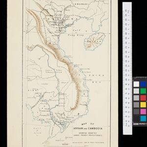
Map of Annam and Cambodia showing country under French protectorate
1885
Cambodia, Laos, Thailand, Vietnam
Map showing the French protectorate territories of mainland Southeast Asia: Annam, Tongking and French Cochin China (modern Vietnam) and Cambodia. Some parts of Siam (Thailand) and Laos are also shown.

Plan topographique de l'arrondissement de Saigon
1885
Vietnam
Map of the district of Saigon (Ho Chi Minh City, Vietnam), based around the Fleuve Soirap (Soài Rạp River) as it winds its way down to the South China Sea. The city of Saigon is on its banks, surrounded by more rivers, roads, fields and villages.

- Filter from 1478 to 1900
- French192
- Latin180
- English179
- Dutch86
- German73
- Italian19
- Spanish2
- Portuguese1
- more Language »
- [remove]Vietnam670
- Cambodia625
- Thailand624
- Malaysia613
- Myanmar594
- Laos593
- Indonesia588
- Singapore574
- Brunei559
- Philippines555
- Southeast Asia519
- East Timor489
- more Simple Location »
- Sumatra553
- Borneo541
- Java485
- Malay Peninsula440
- Sulawesi432
- Celebes359
- Siam321
- Western New Guinea304
- Maluku Islands290
- Pegu233
- Sunda Islands228
- Malacca210
- more Detailed Location »


