
Search Results

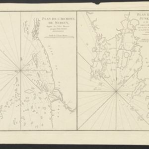
Plan de l'Archipel de Merguy / Plan de l'Isle Junkseilon
1775
Myanmar, Thailand
Two coastal navigation maps: one of the Mergui Archipelago off the west coast of Myanmar; and one of Phuket (‘Isle Junkseilon’) and the surrounding islands off the west coast of Thailand. Both feature bathymetry (sea depth), shoals and reefs.

Carte de la Côte de Pégou, et de celle de Martaban
1775
Myanmar
Navigation map of the coast of the ancient kingdom of Pégou and near the town of Martaban (Mottama), Myanmar. Bathymetry (sea depth), anchor points, notes on currents and obstructions are marked, and there are drawings of side views of coastal hills.

Plan de l'Archipel de Merguy / Plan de l'Isle Junkseilon
1775
Myanmar, Thailand
Two coastal navigation maps: one of the Mergui Archipelago off the west coast of Myanmar; and one of Phuket (‘Isle Junkseilon’) and the surrounding islands off the west coast of Thailand. Both feature bathymetry (sea depth), shoals and reefs.
Carte de la Côte de Pégou, et de celle de Martaban
1775
Myanmar
Navigation map of the coast of the ancient kingdom of Pégou and near the town of Martaban (Mottama), Myanmar. Bathymetry (sea depth), anchor points, notes on currents and obstructions are marked, and there are drawings of side views of coastal hills.


