British Burma is coloured pink on this six-sheet map of India. Mountains are represented by hachures—short lines/dashes that give a sense of the shape and steepness of terrain—and settlements, railways, roads, rivers and lighthouses are marked.
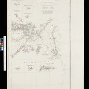
Burma-Siam boundary
event1897
location_onThailand, Myanmar
A topographic map of the Burma-Siam (Myanmar-Thailand) border spread over six sheets. High points are marked with their heights so they can be used for triangulation. Settlements and streams are also shown.
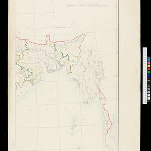
Map of Tennasserim
event1897
location_onMyanmar, Thailand
The border of the Tenasserim Division of British Burma (Tanintharyi Region, Myanmar) is highlighted in orange on this set of six map sheets, showing the boundary with Siam (Thailand) to the east, and the islands off the west coast.
India shewing railways
event1897
location_onMyanmar
This map of India and Burma (Myanmar) shows railways, and railways sanctioned or under construction. Other maps in this series show the same area in different years of the 1890s.
Districts Bhamo and Myitkyina
event1896
location_onMyanmar
Map of two districts in northern Burma (Myanmar) featuring the Irrawaddy River, the Burma State Railway (and others under construction), and mines (ruby, amber, jade). High points are marked with their heights so they can be used for triangulation.
Upper Burma: With additions and corrections to 1896
event1896
location_onMyanmar
Map of Upper Burma divided into Divisions and Districts, and featuring the Irrawaddy and Chindwin rivers, the Burma State Railway, and settlements including the city of Mandalay.
India shewing railways with stations
event1896
location_onMyanmar
This map focuses on India, but also includes Burma (Myanmar), showing the country’s railway lines with their stations, including engine changing stations and junction stations. Part of a series of maps charting the development of the railway system.
India shewing railways
event1896
location_onMyanmar
This map of India and Burma (Myanmar) shows railways, and railways sanctioned or under construction. Other maps in this series show the same area in different years of the 1890s.
India
event1895
location_onMyanmar
On this map of India, Burma (Myanmar) is divided into administrative regions. Borders with India and Siam are hand-coloured.
Upper Burma
event1895
location_onMyanmar, Thailand
Map of Upper Burma, showing the borders with Assam (India), China and Siam (Thailand), as well as internal administrative borders. Mountains with their heights, settlements, rivers and railways (completed, proposed and under construction) are shown.
India
event1895
location_onMyanmar, Thailand
Although this map focuses on India, it also includes Burma (Myanmar), showing the administrative districts that existed under British colonial rule in the late 19th century. Burma's national borders are orange (with India) and red (with Siam).
India
event1895
location_onMyanmar, Thailand
Although this map focuses on India, it also includes Burma (Myanmar), showing the administrative districts that existed under British colonial rule in the late 19th century.