
Search Results


Kaart van assistent-residentie Patjitan
1859
Indonesia
Map of the residency of Patjitan (Pacitan), south coast of East Java, divided into administrative districts. At the base, there is an elevation (side view) drawing of terrain around the Bay of Patjitan. Villages, forts and ruined temples are marked.


Kaart van de westerhelft der residentie Rembang
1858
Indonesia
Topographic map of the residency of Rembang, Central Java, divided into regencies and districts. Roads and villages are marked, with shoals, reefs and water depth at sea. An inset map of the city of Rembang features markets, warehouses, churches.
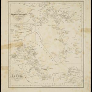
Kaart van den archipel van Riouw, Singapore en Lingga / Kaart van de eilanden Bangka en Blitong
1857
Indonesia, Singapore
Two maps featuring many of the islands between the Malay Peninsula, Sumatra and Borneo. In the top map, Batam, Bintan, Lingga and many of the smaller Riau Islands. In the bottom map, Bangka and Belitung on the east coast of Sumatra.


