
Search Results
265 Results found

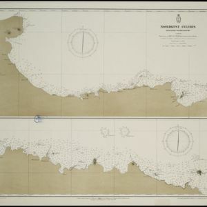
Noordkust Celebes: Hoek Kandi tot hoek Dondo
1899
Indonesia
Two navigation maps for the north coast of Celebes (Sulawesi), featuring bathymetry (sea depth), landmark mountains, reefs and shoals. Obstructions in the water are marked ‘kr’ (coral), ‘m’ (mud), ‘s’ (shells), ‘st’ (stones), and ‘z’ (sand).


Noordkust Celebes: Hoek Samija tot hoek Doelang
1899
Indonesia
A navigation map for the north coast of Celebes (Sulawesi), featuring bathymetry (sea depth), reefs and shoals. Obstructions in the water are marked ‘kr’ (coral), ‘m’ (mud), ‘st’ (stones), and ‘z’ (sand). Five additional maps show details of rivers.

Vaarwaters en ankerplaatsen op de oostkust van Borneo: Blad III
1899
Indonesia
Navigation maps of two bays on the southeast coast of Borneo. Anchorages, bathymetry (sea depth), buoys, shoals and other obstructions are shown. There is an inset map of the roadstead—a body of water sheltered from tides/currents—at Balikpapan Bay.

Zuidelijk gedeelte van de Chineesche zee: Blad I
1899
Malaysia, Singapore, Indonesia
Navigation map of the southern part of the South China Sea, including the straits of Malacca and Singapore, and the Riau Archipelago. Bathymetry (sea depth), lighthouses, shoals and other obstructions are marked, with hills to use as landmarks.


Het door Nederland bezette gebied van Groot-Atjeh met de naaste omgeving
1899
Indonesia
Map focusing on Kota Radja (city of Banda Aceh, Sumatra) during the Aceh War (1873–1904) fought between the Sultanate of Aceh and Dutch colonists. Dutch forts are shown in a zone around the city, and villages are marked in the surrounding country.

Landbouw-ondernemingen in de afdeelingen Deli, Batoe Bahara en Asahan (Residentie Oostkust van Sumatra)
1898
Indonesia
On this map of the east coast of northern Sumatra, red borders divide the land into agricultural properties, each with a number to identify it. The whole area is divided into colour-coded administrative districts.


- Filter from 1596 to 1899
- Indonesia258
- Malaysia151
- Singapore146
- Brunei145
- Thailand142
- Cambodia137
- Philippines137
- Vietnam136
- Myanmar124
- Laos123
- East Timor118
- Southeast Asia113
- more Simple Location »


