
Search Results


Schetskaart der afdeeling Westkust van Atjeh
1888
Indonesia
From a Dutch geographical society journal, this map of the west coast of Atjeh (Aceh), Sumatra, shows shoals, reefs, bathymetry (sea depth) and anchor points. On land, there are mountains (with heights), rivers, pepper plantations and rice fields.


Het Eiland Java: zoo als het sederd de tyden der Portugysen by de Ed. Oost-Indize maatschappye bekend geworden en bevaren is
1714
Indonesia
Published in the early 18th century by the Dutch publisher Pieter van der Aa (1659–1733), this map of Java and the Java Sea is decorated with a colourful painted scene of merchants and boats at a trading port.

Les Îles Moluques, tres exactement representées selon les plus nouvelles Observations des meilleurs Geographes
c.1714-1729
Indonesia
A map of a small island chain off the west coast of the island of Gilola (modern Halmahera in the Maluku Islands of Indonesia). The military forts on the islands were used by the European colonial powers during conflicts over the area’s spice trade.
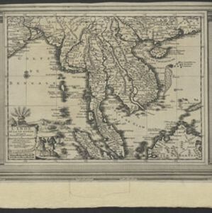
L'Inde de la Le Gange
1713
Brunei, Cambodia, Indonesia, Laos, Malaysia, Myanmar, Thailand, Vietnam
This map of mainland Southeast Asia features a label describing the local population of the mountains of Cochinchine (Vietnam) as ‘les Kemoi Sauvages [the Kemoi savages]’. The cartouche features a drawing of Asia with people, fields and palm trees.
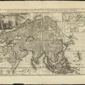
L'Asie, selon les nouvelles observations de Messrs. de l'Academie des Sciences
1713
Brunei, Cambodia, East Timor, Indonesia, Laos, Malaysia, Myanmar, Philippines, Singapore, Southeast Asia, Thailand, Vietnam
This early 18th century map of Asia features a drawing of a woman burning offerings on an altar, while two children carry cornucopias, and a camel looks on. The Roman god Mercury descends from the sky in the background wearing his winged helmet.
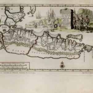
'T koninkryk Sunda met dat van Iava by d'Inwoonderen voor een Eiland
1707
Indonesia
Java is shown as two separate islands on this map, with the western island named Sunda. The southern coast is labelled as ‘unknown’. A colourful cartouche is decorated with a painting of indigenous Javanese people meeting and trading with Europeans.


