Search Results
139 Results found


Kaart van het gebied bezet in Groot-Atjeh, met de nederzettingen Lepoeng en Lehoeng
1897
Indonesia
A map of Groot-Atjeh, Lepoeng and Lehoeng, at the northern tip of Sumatra, detailing routes (rivers, roads, railways), crops (rice, banana, sugarcane, betel, pepper, alang-alang, bamboo) and land features (forests, mountains, wetlands).


Topographische kaart der residentie Bantam
1897
Indonesia
The residency of Bantam, West Java, shown over nine sheets. Coffee and tea plantations, fields of rice, alang-alang, bamboo and other crops are marked. Inset maps show distances by road and path, and the area divided into regencies and districts.

Atlas van Nederlandsch Oost-Indië
c.1897-1904
Indonesia
Very detailed atlas of the entire Dutch East Indies, over 16 map sheets, with a cover and overview map. Includes topographic maps, inset maps of cities and islands, and maps featuring land and sea routes, languages, geology, colonial territory etc.

Kaart van het gebied bezet in Groot-Atjeh, met de nederzettingen Lepoeng en Lehoeng
1897
Indonesia
A map of Groot-Atjeh, Lepoeng and Lehoeng, at the northern tip of Sumatra, detailing routes (rivers, roads, railways), crops (rice, banana, sugarcane, betel, pepper, alang-alang, bamboo) and land features (forests, mountains, wetlands).

Topographische Kaart der residentie Bantam
1897
Indonesia
The residency of Bantam, West Java, shown over nine sheets. Coffee and tea plantations, fields of rice, alang-alang, bamboo and other crops are marked. Inset maps show distances by road and path, and the area divided into regencies and districts.

Topographische Kaart der residentie Batavia
1897
Indonesia
The residency of Batavia, West Java, featuring plantations (coffee, tea, coconut, cinnamon, nutmeg, sugar); crops (rice, alang-alang, bamboo); fishing ponds; factories, warehouses, shops; routes, administrative borders; mountains, rivers, lakes.

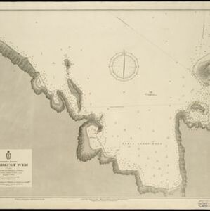
Vaarwaters en ankerplaatsen op de Oostkust van Borneo: Blad I
1896
Indonesia
Four navigation maps of waterways on the northeast coast of Borneo, including the Karang Muaras reef. Anchorages, bathymetry (sea depth), shoals and other obstructions are shown, with trees, hills and elevations (side views of hills) as landmarks.