
Search Results


Kaart van de residentie Oostkust van Sumatra
1889
Indonesia
Detailed topographical map of the east coast of Sumatra, spread over 34 sheets. The area’s farms are listed and shown on the map, with types of crop grown. With five inset maps of individual towns. Two sheets and the cover sheet are missing.

Kaart van de residentie Oostkust van Sumatra
1889
Indonesia
Detailed topographical map of the east coast of Sumatra, spread over 36 sheets plus a cover sheet of the whole area. Mountains and forests dominate, with villages, routes and administrative borders shown. With five inset maps of individual towns.


Kaart van den vierkanten paal (I en II) gouvernements grondgebied te Sintang
1888
Indonesia
The Kapoewas (Kapuas) and Melawi rivers converge on this map of the town of Sintang, Borneo. The town lines the river banks, and is surrounded by fields, forest and marshland. Arrows on the rivers mark the direction of their flow.


[Schetskaarten van versterkingen, loopgraven, stellingen, bentengs e.d. uit de Atjeh oorlog]
1880
Indonesia
Multiple maps from the Aceh War, spread over 12 sheets. Includes maps of fortifications, trenches, battle formations; building plans, including the Aceh Sultan’s palace; topographic maps; and drawings of a ‘kotta mara’ (fortified raft).

Algemeene kaart van Nederlandsch Indië
1879
Cambodia, Indonesia, Papua New Guinea, East Timor, Southeast Asia, Thailand, Malaysia, Philippines, Laos, Vietnam, Singapore, Brunei, Myanmar
A late 19th century map of the Dutch East Indies on four sheets, detailing maritime routes around the region. There are also inset maps showing railways, rivers, roads, and telegraph systems, as well as individual islands and cities.


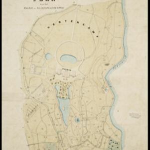
Buitenzorg: Plan van het Paleis en 's Landsplantentuin
1867
Indonesia
Plan of the palace and botanical gardens in Buitenzorg (Bogor, Java). The palace (now known as Bogor Palace) has a lake and deer park, while the gardens (Bogor Botanical Gardens) is divided into plots for types of plants (fruit plants, seed plants).


