Search

Search Results

Military map of the Isle of Luzon

event1900

location_onPhilippines

A map of Luzon, Philippines divided into military and civilian regions. Made for the American military, it features roads, railways, telegraph lines, mountains and rivers. An inset map of Manila shows military, civil and religious buildings.

Manila

event1899

location_onPhilippines

Plan of the city of Manila, Philippines, showing the streets and buildings—categorised as military, civil or religious—around the Pasig River. Maritime routes are highlighted on inset maps of Manila Bay, the Philippines and the world.

Manila, sus arrabales

event1898

location_onPhilippines

A late 19th century plan of the city of Manila, Philippines, showing the streets and buildings—categorised as military, civil or religious—around the Pasig River. The city is surrounded by suburbs, fields and wetlands.

Kaart der hoofdplaats Batavia omstreeks het jaar 1740

event1898

location_onIndonesia

A mid-18th century map of the important port of Batavia (Jakarta), with military forts, a pier, hospitals, churches, and residential streets. However, the city is also surrounded by fields and plantations, for producing crops and grazing animals.

Hoofdplaats-Medan

event1895

location_onIndonesia

Map of the city of Medan on the north coast of Sumatra, featuring the Deli and Babura rivers and two railway lines. Other notable locations include a race track, military camp, Sultan’s palace (Maimun Palace), police station, offices, hospitals etc.

City of Mandalay and environs

event1894

location_onMyanmar

Map of the Burmese city of Mandalay on the Irrawaddy River. The city has a grid of roads and buildings, dominated by Fort Dufferin (formerly Mandalay Palace). The surrounding country has villages, crops, agricultural ponds and irrigation channels.

Java

event1890

location_onIndonesia

This detailed late 19th century map shows Java divided into regencies, and features mountains, roads, railways, and rivers. There is also an inset map of the port city of Batavia (Jakarta).

Kaart van de Hoofdplaats Djokjakarta en Omstreken

event1872

location_onIndonesia

Map of the city of Djokakarta (Yogyakarta, Java), featuring streets and buildings, as well as a military fort, public square and railway station. The surrounding area has rice (paddy) fields and villages.

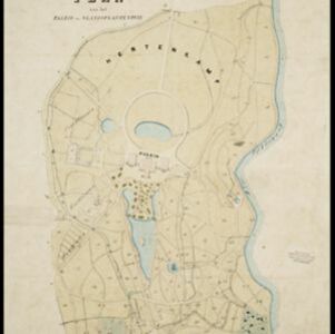
Buitenzorg: Plan van het Paleis en 's Landsplantentuin

event1867

location_onIndonesia

Plan of the palace and botanical gardens in Buitenzorg (Bogor, Java). The palace (now known as Bogor Palace) has a lake and deer park, while the gardens (Bogor Botanical Gardens) is divided into plots for types of plants (fruit plants, seed plants).

Plattegrond der stad Batavia

event1866

location_onIndonesia

A mid-19th century map of the important port of Batavia (Jakarta), with its pier, commercial centre and residential streets. However, the city is also surrounded by villages (kampongs), fields and plantations. An inset map shows Batavia Castle.

Kaart der residentie Soerakarta

event1859

location_onIndonesia

The residency of Soerakarta in Central Java is shown divided into regencies (yellow borders) and districts (blue borders). There is an inset plan of the capital city, Soerakarta (modern Surakarta), and mountains and land routes are marked.

Der Hollaendisch-Ostindianischen Compagnie weltberühmte Haupt-Handels und Niederlags: Stadt Batavia

event1747

location_onIndonesia

The legend and written notes on this plan of Batavia (Jakarta) provide much detailed information about the important port city in the early 18th century. It is also beautifully decorated with paintings of the city, local people, animals and ships.

close