Search

Search Results

Isles de la Sonde vers l'Orient

event1683

location_onEast Timor, Indonesia, Philippines

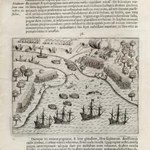
French text on the reverse of this map of the eastern Sunda Islands describes the city of Macassar (modern Makassar) on Celebes (Sulawesi, Indonesia). Details include the city’s port, trade and crops, as well as its people and religion.

Citadelle de Batavia

event1683

location_onIndonesia

These two paintings show the port of Batavia (Jakarta) from the sea. The upper image focusses on the castle, while the lower image depicts a sea battle—possibly a 1618 battle between the British and Dutch—with the city in the background.

The Molucca Ilands &c.

eventc.1680-1700

location_onEast Timor, Indonesia, Philippines

From Robert Morden’s ‘Geography Rectified’, a description with maps of the known world in the late 17th century. The map shows the Moluccas, but the text describes the Philippines: Spanish colonial rule, trade, the city of Manila and port of Cavite.

A new plaine and exact map of Asia

event1671

location_onBrunei, Cambodia, East Timor, Indonesia, Laos, Malaysia, Myanmar, Philippines, Singapore, Southeast Asia, Thailand, Vietnam

This colourful map of Asia is illustrated with drawings of Asian people wearing traditional clothing, including a man and woman from Java in Southeast Asia, and drawings of important ports such as Bantan (Banten) situated at the western end of Java.

Ware affbeeldinge wegens het casteel ende stadt Batavia gelegen opt groot eylant Java anno 1669

event1670

location_onIndonesia

A plan of the important port of Batavia (Jakarta), with the fort, river, city streets and fields. Decorative illustrations include ships in the harbour, a view of the city and mountains, and the city’s coat of arms: a lion holding a sword and shield.

Insularum Moluccarum nova descriptio

eventc.1641-1651

location_onIndonesia

A mid-17th century map by the Dutch cartographer Jan Jansson, depicting a small chain of six islands off the west coast of Gilolo (modern Halmahera, in the Indonesian Maluku Islands). German text on the reverse describes the Maluku Islands.

Solor

eventc.1631-1657

location_onIndonesia

From Ludwig Johann Gottfried’s ‘Newe welt und Americanishe historien’, a drawing of warships—probably Dutch and Portuguese—fighting in the harbour of the volcanic island of Solor (Lesser Sunda Islands). German text describes the region.

Insulæ Indiæ orientalis præcipuæ: in quibus Moluccæ celeberrimæ sunt

event1623

location_onBrunei, Cambodia, East Timor, Indonesia, Laos, Malaysia, Myanmar, Philippines, Singapore, Southeast Asia, Thailand, Vietnam

On the right of this map, Latin text held within an elaborate border notes that five of the Maluku Islands are located nearby—Ternate, Tidore, Moti, Makian and Bacan—which trade spices including clove, cinnamon, nutmeg and ginger to the world.

Moluccæ insulæ

event1618

location_onIndonesia, East Timor

Unusually, north is located to the right of this early 17th century map of the Maluku Islands, rather than the top. The scale is shown on a stone monument. French text on the reverse describes Java.

Malacca

event1616

location_onBrunei, Cambodia, Indonesia, Laos, Malaysia, Myanmar, Singapore, Thailand, Vietnam

French text on the back of this map of mainland Southeast Asia describes the kingdom of Pegu (Myanmar), its royal palace, ports and trade with Sumatra and Malacca (rice, butter, oil, salt, onions, silver, porcelain, quicksilver, copper, pewter etc.).

Baly

event1616

location_onIndonesia

This early 17th century map of the island of Bali shows palaces, settlements and possibly some temples. Ships can be seen at anchor around the coast. The map is from a Latin language book which includes text describing Bali.

[Town of Madura with four ships of Houtman's fleet]

event1614

location_onIndonesia

Two pages from ‘Rerum et urbis Amstelodamensium historia’ by Johannes Pontanus, featuring a drawing of the attack on Madura by the ships of the Dutch merchant seaman Cornelis de Houtman, in revenge for an unrelated pirate attack.

close