
Search Results
793 Results found


Overzichtskaart van Groot-Atjeh en aangrenzende kuststaten
1898
Indonesia
Map of Groot-Atjeh (Aceh, Sumatra), focusing on the area around the capital Kota Radja (Banda Aceh) and along the coasts. There is a list of telephone connections in the area, and an inset map of the region divided into administrative districts.

De stad Batavia met derzelver omstreken: Geteekend in 1826
1898
Indonesia
The city of Batavia (Jakarta) with its port and castle is to the north (right side of the map). Koningsplein (Merdeka Square), a large area of rice paddies, graveyards and villages can be seen to the south (left). Copied from a c.1826 map.


Situatieplan van Batavia desselfs stranden en ommelanden
1898
Indonesia
Plan of the city of Batavia (Jakarta), its suburbs and surrounding areas, focussing on the river and canal system. This is a copy of an original c.1790 map. The pier has been pencilled in, as it was not built when the original map was produced.

Westkust Celebes: Vaarwaters benoorden Makasser: Blad I
1898
Indonesia
Navigation map of the west coast of Celebes (Sulawesi), north of Makassar. Bathymetry (sea depth), lighthouses, shoals and other obstructions are marked, with trees and hills as landmarks, and elevations (side views of hills) to aid navigation.

Westkust Celebes: Vaarwaters benoorden Makasser: Blad III
1898
Indonesia
Navigation map of the west coast of Celebes (Sulawesi), north of Makassar. Bathymetry (sea depth), shoals and other obstructions are marked, with hills and settlements as landmarks, and elevations (side views of hills) to aid navigation.

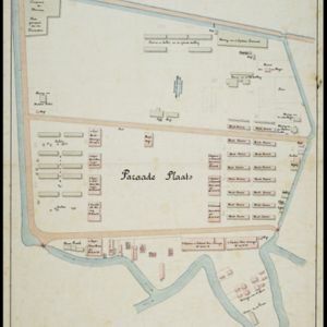
Plattegrond van de stad en casteel Batavia, met de daarnaast gelegene situatie
1898
Indonesia
Plan of the port city of Batavia (Jakarta) with the pier (and North) at the bottom. There is a legend, and an illustrated cartouche featuring a female figure holding an oar and a shield decorated with the ‘VOC’ logo of the Dutch East India Company.
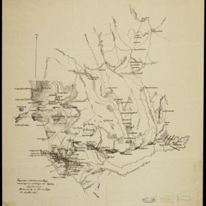

Schetskaart van het Toba-meer en aangrenzende landstreken
1898
Indonesia
Map of Lake Toba and the surrounding area in northern Sumatra, featuring mountains, forests, types of terrain (undergrowth, field, grass), rivers, roads and settlements. There is an inset map that shows the other maps referenced in producing the map.

- Indonesia718
- Malaysia364
- Singapore324
- Thailand315
- Brunei301
- Vietnam292
- Cambodia285
- Myanmar285
- Philippines283
- East Timor274
- Laos260
- Southeast Asia238
- more Simple Location »
- Port117
- Pier52
- Railway Station39
- River576
- Road224
- Path123
- Railway/Tramway88
- Postal Route62
- Canal57
- Bridge54
- Telegraph/Telephone24


