
Search Results


Kaart de residentie Wester-afdeeling van Borneo
1898
Indonesia
Topographical map of western Borneo, with inset maps of the islands off the west coast, and of the city of Pontianak including the docks and crops grown near the city (rice, coconut, mangosteen, sago, alang-alang, indigo plant, sugarcane, bamboo).

Kaart van het kasteel en de stad Batavia in het jaar 1667
1898
Indonesia
Very detailed map of the port city of Batavia (Jakarta), with numerous locations listed in the multiple legends. The city’s coat of arms—featuring a sword and laurel wreath—and the Dutch East India Company monogram logo—letters ‘VOC’—are also shown.

Landbouw-ondernemingen in de afdeelingen Deli, Batoe Bahara en Asahan (Residentie Oostkust van Sumatra)
1898
Indonesia
On this map of the east coast of northern Sumatra, red borders divide the land into agricultural properties, each with a number to identify it. The whole area is divided into colour-coded administrative districts.

Kaart van Batavia omstreeks 240 jaren geleden overgebracht in 1864
1898
Indonesia
Although published in the 19th century, this is a copy of a much earlier map of Batavia (Jakarta) from c.1625. It focuses on the castle and fortifications, but also shows the fields of crops and wetlands surrounding the city.


Plattegrondtekening der vestingwerken van de stad en 't kasteel Batavia
1898
Indonesia
Hand-drawn and coloured plan of the fortifications at Batavia (Jakarta, Java) including the castle, city walls, and moat and canal system. An inset map features four more of the city’s fortifications. This is a copy of an original 1788 map.
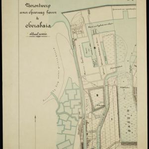
Voorontwerp eener spoorweghaven te Soerabaia
1898
Indonesia
Spread over four sheets, this is a detailed hand-drawn plan for railway and tramway lines at the port of Soerabaia (Surabaya, East Java). It includes a railway station, commercial areas, housing, customs, warehouses, offices and government buildings.


- Indonesia520
- Malaysia256
- Thailand227
- Singapore224
- Brunei208
- Vietnam203
- Cambodia199
- Myanmar196
- Philippines196
- Laos185
- East Timor184
- Southeast Asia164
- more Simple Location »
- Java329
- Sumatra314
- Dutch East Indies270
- Borneo247
- Malay Peninsula217
- Sulawesi199
- Celebes159
- Western New Guinea137
- Maluku Islands136
- Siam115
- Sunda Islands105
- Malacca99
- more Detailed Location »
- Port81
- Pier39
- Railway Station35
- [remove]River576
- Road204
- Path113
- Railway/Tramway73
- Canal57
- Bridge52
- Postal Route52
- Telegraph/Telephone18


