
Search Results


The Island of Ceylon / Burmah, Siam and Anam
1870
Myanmar, Laos, Cambodia, Thailand, Vietnam, Malaysia
This map of mainland Southeast Asia has colour-coded borders: Burmah (Myanmar) in red, Siam (Thailand) in brown, and Anam (Vietnam) in green. The British territory of Penang is also bordered in red. Independent areas are bordered in grey.

[Manuscript map of Asia and Australia]
1870
Southeast Asia, Singapore, Brunei, Cambodia, East Timor, Indonesia, Laos, Malaysia, Myanmar, Papua New Guinea, Philippines, Thailand, Vietnam
On this hand-drawn and coloured map of Asia, the colours differentiate the colonial territories of the European powers: for example, New Guinea is divided into Dutch, British and German areas, and Borneo is split between the British and Dutch.

Ostindische Inseln
c.1870
Brunei, Cambodia, East Timor, Indonesia, Laos, Malaysia, Myanmar, Philippines, Singapore, Southeast Asia, Thailand, Vietnam
On this map of Southeast Asia, borders are outlined and cities underlined in different colours to show the colonial territories of the European powers. On Borneo, the names of indigenous peoples are listed (‘Dayak’s, Papua’s, Bugi’s’).
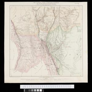
The central part of British Burmah with the Shan provinces of Burmah and Siam
1870
Myanmar, Thailand
The routes of eight expeditions through Burma (Myanmar) and Siam (Thailand) are shown, with text noting ‘Ancient ruins with sarcophagi, mummies’, ‘bazaar… great variety of European goods’, ‘great thoroughfare for the Chinese trading with the Shans’.

Ostindische Inseln
c.1870
Brunei, Cambodia, East Timor, Indonesia, Laos, Malaysia, Myanmar, Philippines, Singapore, Southeast Asia, Thailand, Vietnam
On this map of Southeast Asia, borders are outlined and cities underlined in different colours to show the colonial territories of the European powers. On Borneo, the names of indigenous peoples are listed (‘Dayak’s, Papua’s, Bugi’s’).
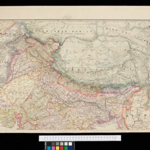
Stanford's portable map of India shewing its present divisions and the adjacent parts of Beluchistan, Afghanistan, Turkestan, the Chinese Empire, Burmah and Siam
1869
Myanmar, Indonesia, Thailand
This two-sheet map of India includes Burma (Myanmar) and Siam. British Burma—which came under British colonial rule after the first (1824–1826) and second (1852–1853) Anglo-Burmese wars—is highlighted in red.

Oost-Indie
c.1867
Brunei, Cambodia, East Timor, Indonesia, Laos, Malaysia, Myanmar, Philippines, Singapore, Southeast Asia, Thailand, Vietnam
Map of the East Indies in the mid-19th century, with Dutch colonial territory (Dutch East Indies) coloured in brown. Dutch administrative regions—such as residencies (‘residentie’) and governorates (‘gouvernement’)—are labelled.

Military cantonments: town and suburbs of Akyab, 1853-54
1866
Myanmar
Plan of British military installations in the port town of Akyab, Burma (Sittwe, Myanmar), featuring piers on the Kolladyne River (Kaladan River), hospitals, a work house, mission house, hotel, bazaar, burial grounds, religious buildings etc.

Stanford's library map of Asia
1862
Brunei, Cambodia, East Timor, Indonesia, Laos, Myanmar, Malaysia, Philippines, Singapore, Southeast Asia, Thailand, Vietnam
Map of Asia on four sheets, with Southeast Asia on sheet four. British colonial territory—British Burma, the Straits Settlements, Sarawak—is highlighted in red, with the Dutch East Indies, Spanish Philippines and Portuguese East Timor also shown.

Extension of the Electric Telegraph to Canton, Hong Kong, etc. from the Port of Rangoon
1860
Myanmar, Cambodia, Indonesia, Laos, Malaysia, Singapore, Thailand, Vietnam
Map of a proposed extension of a telegraph system from Rangoon (Yangon, Myanmar) to China. Includes current and projected railways, steam ship routes, and population figures for western China. From the British magazine ‘The Illustrated London News’.
- Filter from 1700 to 1900
- [remove]Myanmar132
- Thailand106
- Malaysia94
- Indonesia88
- Vietnam88
- Cambodia86
- Laos86
- Singapore85
- Brunei72
- Southeast Asia67
- Philippines66
- East Timor62
- more Simple Location »


