Search

Search Results

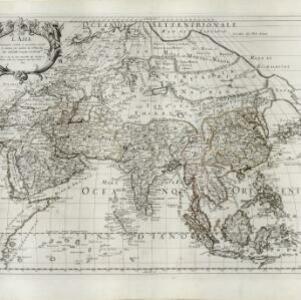
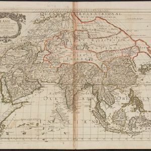
L'Asie distinguée suivant l'estendue de ses principales parties

event1720

location_onBrunei, Cambodia, East Timor, Indonesia, Laos, Malaysia, Myanmar, Philippines, Southeast Asia, Singapore, Thailand, Vietnam

This two-sheet map of Asia features a decorative cartouche with drawings of two women holding censers (incense burners), two cherubs, and a French coat of arms. On the map, mountains and forests are represented pictorially.

L'Asie divisée en ses principales regions, et ou se peuvent voir l'estendue des Empires, Monarchies, Royaumes, et Estats qui partagent présentement l'Asie

event1720

location_onBrunei, Cambodia, East Timor, Indonesia, Laos, Myanmar, Malaysia, Papua New Guinea, Philippines, Singapore, Southeast Asia, Vietnam, Thailand

This map shows the empires, kingdoms and states of Southeast Asia. Its decorative cartouche features drawings of two women—one with a cornucopia and one with a censer (incense burner)—elephant heads, and a French coat of arms. Nine scales are shown.

L'Asie divisée en ses principales regions, et ou se peuvent voir l'estendue des Empires, Monarchies, Royaumes, et Estats qui partagent présentement l'Asie

event1720

location_onBrunei, Cambodia, East Timor, Indonesia, Laos, Malaysia, Myanmar, Papua New Guinea, Philippines, Singapore, Southeast Asia, Thailand, Vietnam

This map shows the empires, kingdoms and states of Southeast Asia. Its decorative cartouche features drawings of two women—one with a cornucopia and one with a censer (incense burner)—elephant heads, and a French coat of arms. Nine scales are shown.

Insulae Iavae pars Occidentalis

eventc.1720

location_onIndonesia

A map of west Java with mountains, jungles, animals and crops. Details include sea depth, an inset map of Batavia harbour, and an illustration of a lion—representing Belgium—receiving tribute and enslaving locals. A similar map of east Java was made.

Insulae Iavae Pars Occidentalis / Insulae Iavae Pars Orientalis

eventc.1720

location_onIndonesia

A map of Java with mountains, jungles, animals and crops. Bathymetry (sea depth) is marked, including on an inset map of Batavia harbour. Illustrations include Batavia Castle, and a lion—representing Belgium—receiving tribute and enslaving locals.

Insulae Iavae pars Occidentalis

eventc.1710-1719

location_onIndonesia

A map of Java with mountains, jungles, animals and crops. Bathymetry (sea depth) is marked, including on an inset map of Batavia harbour. Illustrations include Batavia Castle, and a lion—representing Belgium—receiving tribute and enslaving locals.

'T koninkryk Sunda met dat van Iava by d'Inwoonderen voor een Eiland

event1707

location_onIndonesia

Java is shown as two separate islands on this map, with the western island named Sunda. The southern coast is labelled as ‘unknown’. A colourful cartouche is decorated with a painting of indigenous Javanese people meeting and trading with Europeans.

Asia divided into its principall regions in which may be seen the extent of the Empires, Monarchies, Kingdoms and States which at present divide Asia

event1680

location_onBrunei, Cambodia, East Timor, Indonesia, Laos, Malaysia, Myanmar, Papua New Guinea, Philippines, Singapore, Southeast Asia, Thailand, Vietnam

This late 17th century map of Asia is by William Berry, based on an earlier map by the French cartographer Nicolas Sanson. Dedicated to King Charles II, it features the royal coat of arms of the United Kingdom in its elaborate cartouche.

L'Asia

event1677

location_onBrunei, Cambodia, East Timor, Indonesia, Laos, Malaysia, Myanmar, Philippines, Southeast Asia, Singapore, Thailand, Vietnam

From Giovanni Giacomo de Rossi’s ‘Mercurio Geografico’, this 17th century map of Asia represents mountains, jungles and cities pictorially, with hand-coloured regional borders. The map’s cartouche is decorated with clothing and weaponry.

L'Asie

event1669

location_onBrunei, Cambodia, East Timor, Indonesia, Laos, Malaysia, Myanmar, Philippines, Singapore, Southeast Asia, Thailand, Vietnam

Produced by the French cartographer Nicolas Sanson (1600–1667) in the mid-17th century, this map of Asia features hand-coloured regional borders. Its cartouche features cherubim and decorative scrollwork.

close