
Search Results
Filter
Detailed Location
Celebes
Remove constraint Detailed Location: Celebes
Detailed Location
Malay Peninsula
Remove constraint Detailed Location: Malay Peninsula
Simple Location
Cambodia
Remove constraint Simple Location: Cambodia
282 Results found


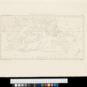


Physical chart of the Indian Ocean: shewing the temperature of the water, the currents of the air and ocean, directions of the wind, districts of hurricanes, regions of the monsoons & ty-foons, trade routes &c&c.
1849
Brunei, Cambodia, East Timor, Indonesia, Laos, Malaysia, Myanmar, Papua New Guinea, Philippines, Singapore, Southeast Asia, Thailand, Vietnam


- Filter from 1575 to 1900
- [remove]Cambodia282
- Indonesia282
- Malaysia282
- Thailand282
- Brunei281
- Singapore281
- Philippines280
- Vietnam280
- Southeast Asia274
- East Timor269
- Myanmar269
- Laos267
- more Simple Location »
- [remove]Celebes282
- [remove]Malay Peninsula282
- Sumatra282
- Borneo280
- Sulawesi278
- Java273
- Western New Guinea191
- Siam187
- Maluku Islands145
- Pegu141
- Malacca130
- South China Sea104
- more Detailed Location »


