Search Results
Filter
Map Attributes
Scale
Remove constraint Map Attributes: Scale
Detailed Location
Sumatra
Remove constraint Detailed Location: Sumatra
Simple Location
Malaysia
Remove constraint Simple Location: Malaysia
Transport Hubs
Port
Remove constraint Transport Hubs: Port
20 Results found
![](https://historicalmaps.yale-nus.edu.sg/rails/active_storage/representations/eyJfcmFpbHMiOnsibWVzc2FnZSI6IkJBaHBBcXNEIiwiZXhwIjpudWxsLCJwdXIiOiJibG9iX2lkIn19--b07316412ad3e99d5df728b6ae567ddd1413f11d/eyJfcmFpbHMiOnsibWVzc2FnZSI6IkJBaDdCam9MY21WemFYcGxTU0lNTkRBd2VETXdNQVk2QmtWVSIsImV4cCI6bnVsbCwicHVyIjoidmFyaWF0aW9uIn19--bc467f5637e8b6d3bfb826116f92b6bfedfbf03a/beinecke-15510696.jpeg)
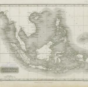
Map of South-Eastern Asia and Northern Australia: showing the districts in Annam and Tonquin which France proposes to annex and to place under a Protectorate, the portion of New Guinea proposed to be acquired by Queensland, and the districts affected by the volcanic eruptions in Java
1883
Southeast Asia, Singapore, Thailand, East Timor, Vietnam, Brunei, Cambodia, Indonesia, Laos, Malaysia, Myanmar, Papua New Guinea, Philippines
![](https://historicalmaps.yale-nus.edu.sg/rails/active_storage/representations/eyJfcmFpbHMiOnsibWVzc2FnZSI6IkJBaHBBcklEIiwiZXhwIjpudWxsLCJwdXIiOiJibG9iX2lkIn19--e07182c5e41a8de0f6e92ed08d7fc244f676d718/eyJfcmFpbHMiOnsibWVzc2FnZSI6IkJBaDdCam9MY21WemFYcGxTU0lNTkRBd2VETXdNQVk2QmtWVSIsImV4cCI6bnVsbCwicHVyIjoidmFyaWF0aW9uIn19--bc467f5637e8b6d3bfb826116f92b6bfedfbf03a/leiden-2011557.jpeg)
A map of the East-Indies and the adjacent countries: with the settlements, factories and territories, explaning what belongs to England, Spain, France, Holland, Denmark, Portugal &c.
c.1720
Brunei, Cambodia, East Timor, Indonesia, Laos, Malaysia, Myanmar, Philippines, Singapore, Southeast Asia, Thailand, Vietnam
![](https://historicalmaps.yale-nus.edu.sg/rails/active_storage/representations/eyJfcmFpbHMiOnsibWVzc2FnZSI6IkJBaHBKdz09IiwiZXhwIjpudWxsLCJwdXIiOiJibG9iX2lkIn19--93ba01433ccf1fa0d701904ce109057740666b42/eyJfcmFpbHMiOnsibWVzc2FnZSI6IkJBaDdCam9MY21WemFYcGxTU0lNTkRBd2VETXdNQVk2QmtWVSIsImV4cCI6bnVsbCwicHVyIjoidmFyaWF0aW9uIn19--bc467f5637e8b6d3bfb826116f92b6bfedfbf03a/bodleian-0229.jpeg)
A map of the East-Indies and the adjacent countries: with the settlements, factories and territories, explaning what belongs to England, Spain, France, Holland, Denmark, Portugal &c.
1720
Brunei, Cambodia, East Timor, Indonesia, Laos, Malaysia, Myanmar, Philippines, Vietnam, Thailand, Southeast Asia, Singapore
- Indonesia20
- [remove]Malaysia20
- Singapore19
- Brunei17
- Myanmar17
- Thailand17
- Cambodia16
- Laos16
- Vietnam16
- East Timor15
- Philippines14
- Southeast Asia12
- more Simple Location »
- [remove]Sumatra20
- Borneo19
- Java18
- Malay Peninsula16
- Celebes13
- Sulawesi13
- Western New Guinea11
- Siam10
- South China Sea9
- Java Sea7
- Malacca7
- Maluku Islands7
- more Detailed Location »
- [remove]Port20
- Pier3
- [remove]Scale20
- Longitude and Latitude19
- Written Note/Details11
- Compass Rose9
- Contour Lines/Elevation5
- Moll, Herman3
- Chatelain, Henri Abraham2
- Derfelden van Hinderstein, Gijsbert Franco von2
- Mercator, Gerhard2
- Arrowsmith, Aaron1
- Bartholomew, John1
- Bertius, Petrus1
- Coryton, John1
- more Map Maker »
- Chez L'Honore & Châtelain Libraires2
- Hendrik Hondius2
- Herman Moll2
- John King2
- A. Baedeker1
- A. Constable & Co.1
- Baldwin & Cradock1
- Charles Knight & Co.1
- more Printer/Publisher »